

Norwell Pinfold plaque

Plaque on Norwell Pinfold Link © Copyright Richard Croft and licensed for reuse under this Creative Commons Licence . Submitted via Geograph
- village
- rural settlement
- geograph
- pinfold
- historic sit...
- grade ii listed
Plaque on The Little Angel Theatre, 14 Dagmar Passage, N1

See TQ3183 : The Little Angel Theatre, 14 Dagmar Passage, N1. © Copyright Mike Quinn and licensed for reuse under this Creative Commons Licence . Submitted via Geograph
- sport
- leisure
- city
- town centre
- geograph
Plaque, Baronscourt

The inscription on the plaque reads, "This anchor which belonged to the French War Vessel "LAUSUN" 28 Guns on which King James 2nd embarked after the battle of the Boyne in Waterford...
- people
- events
- geograph
Memorial plaques

A close up of the two plaques in NG9547 : Memorial plaques by the path. The top plaque is for a Breton father who loved these hills and lochs, whose ashes are nearby, 1944-2001. The lower plaque...
- uplands
- paths
- moorland
- geograph
Plaque remembers William Cecil at Bourne, Lincolnshire

A tablet outside the Burghley Arms in the town centre reminds us that this was the birthplace of the illustrious statesman William Cecil (1520-98), a pillar of state for forty years, trusted...
- people
- events
- city
- town centre
- historic sit...
- geograph
Plaque to Brunel, Clifton Suspension Bridge

On the eastern "squared Pennant rubble pylon" Link . The wording on the plaque is at Link . © Copyright Derek Harper and licensed for reuse under this Creative Commons Licence . Submitted via Geograph
- people
- events
- grade i list...
- historic sit...
- geograph
Plaque on Charles Lamb's house, Colebrooke Row, N1
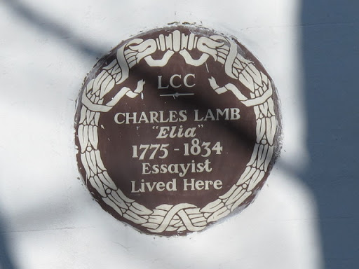
See TQ3183 : Colebrooke Row, N1 (4). © Copyright Mike Quinn and licensed for reuse under this Creative Commons Licence . Submitted via Geograph
- city
- town centre
- historic sit...
- housing
- dwellings
- geograph
Croydon: commemorative plaque

This plaque is attached to the back of a drinking fountain at the junction of Surrey Street and Croydon High Street, the junction often referred to as Millett's Corner. The plaque commemorates the...
- city
- town centre
- roads
- road transport
- geograph
Hynish Signal Tower plaque

Above the door on the east side of the tower. It reads :- Commissioners of Northern Lighthouses 1786 Hynish Signal Tower 1843 In use from 1844 to 1937 for signalling by semaphore to...
- hynish
- tiree
- estuary
- marine
- geograph
- docks
- harbours
- 19th century
- communications
- argyll and bute
- historic sit...
- coastal
- signal tower
- islands
- signalling
- skerryvore l...
Plaque, Aughadarragh National School

Located here H5850 : Former National School, Aghindarragh This reconstructed sandstone plaque was originally positioned at the front wall and is now at the rear of the building. The spelling...
- educational sites
- geograph
Plaque, Queen's View Car Park

The plaque is set into the wall beside the stile at the start of the path up to Auchineden Hill and The Whangie. NS5180 : Auchineden Hill, stile It reads: For your enjoyment of this view...
- paths
- geograph
Plaque re Charles Avison on 55-57 Westgate Road, NE1

See NZ2463 : 55-57 Westgate Road, NE1. The Buildings of Grainger Town - No.190. See NZ2464 : The Earl Grey Monument, Grey Street, NE1. © Copyright Mike Quinn and licensed for reuse under this...
- city
- town centre
- historic sit...
- geograph
Record of replacement over the Tame

This plaque records the replacement of the former Zig-zag Bridge here at Perry Barr, Birmingham by the existing 1930s one which carries the A453 Aldridge Road and traffic on its way to and...
- lowlands
- aldridge road
- west midlands
- public works...
- zig-zag bridge
- a453
- city enginee...
- city of birmingham
- 18th century bridge
- herbert h humphries
- geograph
- birmingham
- suburb
- urban fringe
- perry barr
- 1930s bridge
- councillor t...
Great Casterton: The church of St. Peter and St. Paul: George II coat of arms

© Copyright Michael Garlick and licensed for reuse under this Creative Commons Licence . Submitted via Geograph
- village
- rural settlement
- religious sites
- geograph
Plaque for An Turas

The An Turas is a ferry shelter commissioned by Tiree Arts Enterprise and sponsored by the Scottish Arts Council NM0445 : Cattle holding pen and An TurasNM0445 : The view from An Turas. It was...
- art work
- people
- events
- educational sites
- isle of tiree
- geograph
- an turas
- shelter
- coastal
- islands
- ferry terminal
Llyn Brianne Dam

Information about the Llyn Brianne dam and the company who built it © Copyright Bill Nicholls and licensed for reuse under this Creative Commons Licence . Submitted via Geograph
- commemorative plaque
- historic sit...
- geograph
Plaque on Thomas Coke's house, South Petherton

See also ST4316 : Thomas Coke's house, South Petherton. © Copyright Becky Williamson and licensed for reuse under this Creative Commons Licence . Submitted via Geograph
- village
- rural settlement
- thomas coke
- housing
- dwellings
- house
- geograph
- historic sit...
- village
- somerset
Plaque at St James the Great Church, Wrightington

© Copyright Ian S and licensed for reuse under this Creative Commons Licence . Submitted via Geograph
- village
- rural settlement
- religious sites
- geograph
- church
Plaque at the entrance to Eugene Cross Park, Ebbw Vale

Dedicated to the memory of Eugene Cross (1896-1981), the plaque is on the wall on the left here. Link © Copyright Jaggery and licensed for reuse under this Creative Commons Licence . Submitted via Geograph
- sport
- leisure
- geograph
Mural and Ladle

On Cann Bridge Street, Higher Walter. Link © Copyright Ian S and licensed for reuse under this Creative Commons Licence . Submitted via Geograph
- city
- town centre
- sculpture
- geograph