

Plaque, The Methodist Church, Strabane

It is located on the pavement in front of the church H3497 : Strabane Methodist Church The following text is included in the description: The original Methodist Church was built in Church Street...
- religious sites
- historic sit...
- geograph
Plaque, Dr George Sigerson

Pictured here H3497 : Public library, Strabane © Copyright Kenneth Allen and licensed for reuse under this Creative Commons Licence . Submitted via Geograph
- educational sites
- geograph
Plaque, Ezekiel J Donnell

Pictured here H3497 : Public library, Strabane © Copyright Kenneth Allen and licensed for reuse under this Creative Commons Licence . Submitted via Geograph
- educational sites
- geograph
Diss Mere Fountain stone

At The Mere © Copyright Adrian Cable and licensed for reuse under this Creative Commons Licence . Submitted via Geograph
- stone
- diss
- diss mere fo...
- madgetts walk
- geograph
- closeup
- the mere
- lakes
- wetland
- bog
Alsager: The Guides' Plantation (plaque)

See Link for a view of the trees and their grassy setting. © Copyright Jonathan Hutchins and licensed for reuse under this Creative Commons Licence . Submitted via Geograph
- village
- rural settlement
- alsager
- geograph
Charles Lever plaque, Portstewart

Pictured here C8138 : Burrito / McElhone's, Portstewart © Copyright Kenneth Allen and licensed for reuse under this Creative Commons Licence . Submitted via Geograph
- people
- events
- geograph
Plaque, Tobermore Public Art Project

Pictured here H8396 : Fish sculpture, Tobermore © Copyright Kenneth Allen and licensed for reuse under this Creative Commons Licence . Submitted via Geograph
- public build...
- geograph
The Pound Plaque

Close up of plaque detailing information about "The Pound" © Copyright Stephen Knox and licensed for reuse under this Creative Commons Licence . Submitted via Geograph
- historic sit...
- geograph
Brixworth; All Saints' Church: The Edward Saunders memorial plaque

© Copyright Michael Garlick and licensed for reuse under this Creative Commons Licence . Submitted via Geograph
- village
- rural settlement
- people
- events
- religious sites
- geograph
Plaque on the side of one viaduct pier

This light railway used to be referred to as the Schull and Skibberean Light Railway. © Copyright Martin Southwood and licensed for reuse under this Creative Commons Licence . Submitted via Geograph
- railways
- historic sit...
- geograph
Pudding Plaque

This is the dedication plaque on the pudding stone see TQ5496 : Seat & Millennium Stone © Copyright Glyn Baker and licensed for reuse under this Creative Commons Licence . Submitted via Geograph
- village
- rural settlement
- dedication
- historic sit...
- geograph
Pranket's Well, Stoke Sub Hamdon

Plaque on Pranket's Well. Until the early C20 there was no mains water supply in the village of Stoke Sub Hamdon. While some houses had wells the majority would have to queue to use...
- water resources
- somerset
- well
- geograph
Burford: St John the Baptist Church; Ancient information board

© Copyright Michael Garlick and licensed for reuse under this Creative Commons Licence . Submitted via Geograph
- people
- events
- religious sites
- city
- town centre
- geograph
Dedicatory plaque

Plaque on SY9287 : Streche's Almshouses © Copyright Bob Harvey and licensed for reuse under this Creative Commons Licence . Submitted via Geograph
- lowlands
- 15th century
- geograph
- city
- town centre
- historic sit...
- almshouse
Croesnewydd Sheds

This photograph and plaque is situated within the Morrisons Supermarket which was built on the site of the old 84J Wrexham Locomotive sheds just off the Ruthin Road, in nWrexham. © Copyright...
- lowlands
- construction
- development
- railways
- geograph
- city
- town centre
- business
- retail
- services
Plaque commemorating Dorothy Hodgkin
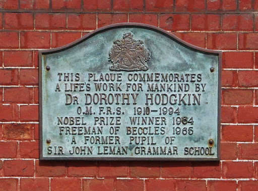
Dr Dorothy Hodgkin was a pioneer in the use of X-ray crystallography to reveal the structure of complex organic molecules. This memorial to her is on the south wall of Beccles Town Hall....
- city
- town centre
- geograph
Mandela Garden, Leeds: plaques

The plaques record (left) the opening of the original garden by Nelson Mandela himself in 1983, (right) the first democratic elections in South Africa in 1994. and (centre) the rededication of the...
- city
- town centre
- nelson mandela
- geograph
Ely: Oliver Cromwell's House; Information Plaque

© Copyright Michael Garlick and licensed for reuse under this Creative Commons Licence . Submitted via Geograph
- people
- events
- city
- town centre
- historic sit...
- geograph
Old Trafford Bridge Plaque

Before the Manchester Ship Canal was built, the course of the River Irwell was approx. 50-100 yards further north of where the Ship Canal now passes under Trafford Road. This plaque is next to a...
- bridge
- nineteenth century
- geograph
- river irwell
- 19th century
- panasonic dmc-g3
- victorian
- rivers
- streams
- drainage
- suburb
- urban fringe
- salford quays
- 1878
- historic sit...
Bridge builder's plaque

On the bridge carrying the unclassified road over the River Almond at the east end of Blackburn. It reads:- 1891 LINLITHGOW COUNTY COUNCIL CAPTN STEUART OF WESTWOOD CONVENER OF BUILDING COMMITTEE....
- lowlands
- bridge
- blackburn
- people
- events
- west lothian
- geograph
- 1891
- almond(west lothian)
- roads
- road transport
- rivers
- streams
- drainage