The Frontenac Road
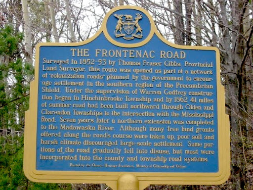
Surveyed in 1852-53 by Thomas Fraser Gibbs, Provincial Land Surveyor, this route was opened as part of a network of "colonization roads" planned by the government to encourage settlement in the southern region of the Precambrian Shield. Under the supervision of Warren Godfrey construction began in Hinchinbrooke Township and by 1862 66 km of summer road had been built northward through Olden and Clarendon Townships to the intersection with the Mississippi Road. Seven years later a northern extension was completed to the Madawaska River. Although many free land grants offered along the road's course were taken up, poor soil and harsh climate discouraged large-scale settlement. Some portions of the road gradually fell into disuse, but most were incorporated into the county and township road systems.
Plaque via Alan L. Brown's site Ontario Plaques. Full page here.