
Castlerigg Stone Circle

Information plaque, near the entrance to the site, showing the layout of the circle. © Copyright Peter Trimming and licensed for reuse under this Creative Commons Licence . Submitted via Geograph
- geograph
- castlerigg
- cumbria
- keswick
- historic sit...
Plaque, Catherine Ford Bridge

Commemorating the rebuilding of the bridge in 1938, and crediting it to Howard Sims Ganderton (1890-1954), Wiltshire's County Surveyor at the time. As explained in SU0030 : Catherine Ford Bridge,...
- bridge parapet
- roads
- road transport
- geograph
St Mary, Newport - Plaque

© Copyright John Salmon and licensed for reuse under this Creative Commons Licence . Submitted via Geograph
- religious sites
- madonna & child
- geograph
Coast and Glens information

An information board at Cushendall. © Copyright Michael Dibb and licensed for reuse under this Creative Commons Licence . Submitted via Geograph
- village
- rural settlement
- estuary
- marine
- coastal
- geograph
O'Kane's Lay-by [3]

An information board in the lay-by. © Copyright Michael Dibb and licensed for reuse under this Creative Commons Licence . Submitted via Geograph
- estuary
- marine
- roads
- road transport
- coastal
- geograph
O'Kane's Lay-by [2]

An information board in the lay-by. © Copyright Michael Dibb and licensed for reuse under this Creative Commons Licence . Submitted via Geograph
- estuary
- marine
- roads
- road transport
- coastal
- geograph
Conjuror's Tower [2]
![The information board adjacent to the tower D3115 : Conjuror's Tower [1]. © Copyright Michael Dibb and licensed for reuse under this Creative Commons Licence . Submitted via Geograph](http://lh3.googleusercontent.com/OD4EjZTfIsVO2ulyzFIhD4-R3H557HA2ZzG7GZT-E9O7eMP1qd0BQcSRfb3_bNR8VKgWPACw1lw4Ep7YWNKOp1neQ4ni4w)
The information board adjacent to the tower D3115 : Conjuror's Tower [1]. © Copyright Michael Dibb and licensed for reuse under this Creative Commons Licence . Submitted via Geograph
- village
- rural settlement
- estuary
- marine
- coastal
- geograph
Welcome to Glenarm

An information board in the marina giving a brief history of the town. © Copyright Michael Dibb and licensed for reuse under this Creative Commons Licence . Submitted via Geograph
- village
- rural settlement
- estuary
- marine
- geograph
- docks
- harbours
- coastal
St Patrick's Hall [2]

The information board attached to the hall. © Copyright Michael Dibb and licensed for reuse under this Creative Commons Licence . Submitted via Geograph
- village
- rural settlement
- housing
- dwellings
- religious sites
- estuary
- marine
- geograph
- coastal
Methodist Chapel [2]

The information board attached to the chapel. © Copyright Michael Dibb and licensed for reuse under this Creative Commons Licence . Submitted via Geograph
- village
- rural settlement
- religious sites
- estuary
- marine
- geograph
- historic sit...
- coastal
The Rope Walk

The information board on the rope walk. © Copyright Michael Dibb and licensed for reuse under this Creative Commons Licence . Submitted via Geograph
- village
- rural settlement
- estuary
- marine
- geograph
- historic sit...
- coastal
Portaferry Castle [2]

The information plaque attached to the castle wall. © Copyright Michael Dibb and licensed for reuse under this Creative Commons Licence . Submitted via Geograph
- village
- rural settlement
- defence
- military
- estuary
- marine
- geograph
- historic sit...
- coastal
Sinclair Seaman's Presbyterian Church [2]
![The information board outside the church. See J3474 : Sinclair Seaman's Presbyterian Church [1] © Copyright Michael Dibb and licensed for reuse under this Creative Commons Licence . Submitted via Geograph](http://lh3.googleusercontent.com/1Fm1v1iLRv1uCuWLYEPopli6chHpQmWf4K2IrfpgrO-12jVVmkvlYAU08jC7G4f8E5bcYgrzHOxXsDXMcBJVMWo29Q4)
The information board outside the church. See J3474 : Sinclair Seaman's Presbyterian Church [1] © Copyright Michael Dibb and licensed for reuse under this Creative Commons Licence . Submitted via Geograph
- religious sites
- city
- town centre
- coastal
- geograph
Harbour office [3]
![The information board outside the Harbour Office. See J3474 : Harbour Office [1] © Copyright Michael Dibb and licensed for reuse under this Creative Commons Licence . Submitted via Geograph](http://lh3.googleusercontent.com/mWo1cxfFJzfwW0_-JR3GhxHWxG4dRH9UyP08PAQcHFc36jgE16G5UkkoVBy9iXkFwfPakEzGf2H_QXUhX1eM5z7lQWY)
The information board outside the Harbour Office. See J3474 : Harbour Office [1] © Copyright Michael Dibb and licensed for reuse under this Creative Commons Licence . Submitted via Geograph
- city
- town centre
- public build...
- coastal
- geograph
Plaque, The Coonian Ghost

It includes the following text: The famous poltergeist is said to have haunted the Murphy farmhouse in the townland of Cornarooslan in this parish in 1913 Pictured here H4642 : Cooneen Ghost House...
- people
- events
- geograph
The Lords Prayer

This can be seen to one side of the ten commandments at St Cewydd, Aberedw © Copyright Bill Nicholls and licensed for reuse under this Creative Commons Licence . Submitted via Geograph
- village
- rural settlement
- religious sites
- geograph
- historic sit...
- parish church
I Believe

This can be seen to one side of the ten commandments at St Cewydd, Aberedw © Copyright Bill Nicholls and licensed for reuse under this Creative Commons Licence . Submitted via Geograph
- village
- rural settlement
- religious sites
- geograph
- historic sit...
- parish church
Harp festival
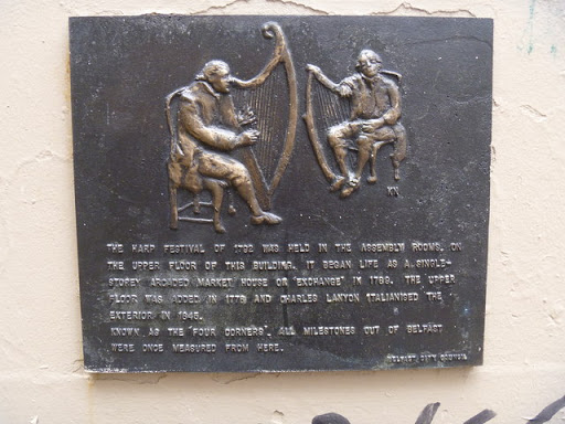
A plaque attached to the Assembly Rooms see J3374 : The Assembly Rooms © Copyright Michael Dibb and licensed for reuse under this Creative Commons Licence . Submitted via Geograph
- city
- town centre
- historic sit...
- coastal
- geograph
First Presbyterian Church [2]

The information board adjacent to the church. © Copyright Michael Dibb and licensed for reuse under this Creative Commons Licence . Submitted via Geograph
- religious sites
- geograph
- city
- town centre
- historic sit...
- coastal
East Castle Street plaque, Bridgnorth

The plaque on the Habit Link at the northern end of the street records that in 1101, houses were built within the outer bailey of Bridgnorth Castle, forming the original East and West...
- city
- town centre
- historic sit...
- geograph