

Church of Ireland cathedral [8]
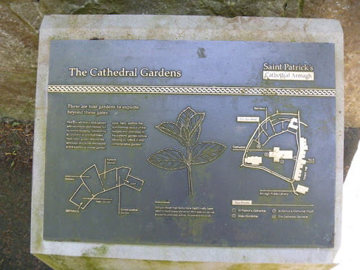
An information board outside the cathedral giving details about the gardens. © Copyright Michael Dibb and licensed for reuse under this Creative Commons Licence . Submitted via Geograph
- lowlands
- religious sites
- geograph
- city
- town centre
- historic sit...
Church of Ireland cathedral [6]
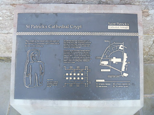
An information board outside the cathedral giving details about the crypt. © Copyright Michael Dibb and licensed for reuse under this Creative Commons Licence . Submitted via Geograph
- lowlands
- religious sites
- geograph
- city
- town centre
- historic sit...
Church of Ireland cathedral [4]

A plaque on the wall of the cathedral about Brian Boroimhh (Brian Boru) an Irish king who was buried at the cathedral. For more information see: Link © Copyright Michael Dibb and licensed for...
- lowlands
- religious sites
- geograph
- city
- town centre
- historic sit...
Church of Ireland cathedral [3]

An information board outside the cathedral about Brian Boroimhh (Brian Boru) an Irish king who was buried at the cathedral. For more information see: Link © Copyright Michael Dibb and licensed...
- lowlands
- religious sites
- geograph
- city
- town centre
- historic sit...
Church of Ireland cathedral [2]
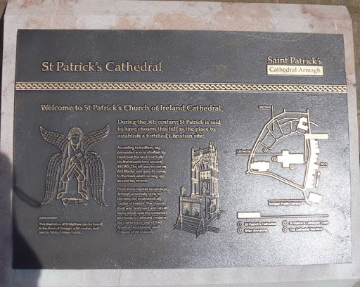
An information board outside the cathedral. © Copyright Michael Dibb and licensed for reuse under this Creative Commons Licence . Submitted via Geograph
- lowlands
- religious sites
- city
- town centre
- geograph
West Chiltington: St. Mary's Church: Memorial plaque

© Copyright Michael Garlick and licensed for reuse under this Creative Commons Licence . Submitted via Geograph
- village
- rural settlement
- people
- events
- religious sites
- geograph
West Chiltington: Information plaque outside St. Mary's Church

© Copyright Michael Garlick and licensed for reuse under this Creative Commons Licence . Submitted via Geograph
- village
- rural settlement
- religious sites
- geograph
South Africa War Memorial, Manchester Cathedral
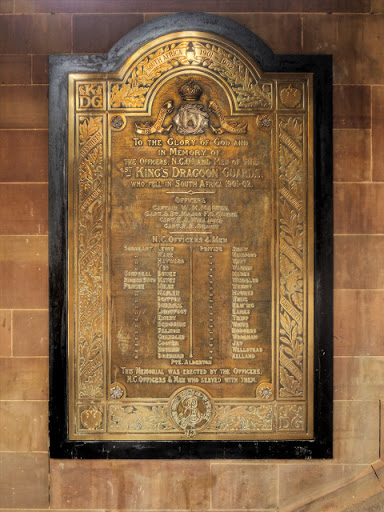
This large brass plaque within a black frame, located within the Cathedrals West Porch, commemorates the men of the 1st Kings Dragoon Guards who died in the Boer War 1901-02. © Copyright David...
- war memorial
- memorial
- south africa...
- tablet
- people
- events
- religious sites
- indoor
- geograph
- manchester c...
- panasonic dmc-g3
- city
- town centre
- historic sit...
- boer war
- brass
- manchester cathedral
Rye: the water tower plaque

An interesting plaque in Church Square, alongside TQ9220 : Rye: the water tower, giving various snippets of historical information about the tower. It finishes with the phrase, "The exact date of...
- water resources
- city
- town centre
- water tower
- geograph
Plaque on shelter, Yarmouth Pier, Yarmouth, Isle of Wight

The plaque is on the shelter, otherwise known as the Round House, and lists people who have made contributions to the repairs of the pierhead. SZ3589 : Shelter or Round House on Yarmouth...
- listed building
- geograph
- sport
- leisure
- city
- town centre
- coastal
- pier
Thomas Sword Good, Painter, lived here
![A grade II-listed 18thC Georgian town house built on the quay wall at Berwick-upon-Tweed, now available for rent as a holiday cottage. Thomas Good [1789-1872] lived here from 1846 until 1872 Link...](http://lh3.googleusercontent.com/k7qdur5cB9t9egGd0K0iabjn9Y-AYn5e_bEqeWhOkBG1t39hmW1PlO8OR5-E7KiPmW2VF-zCay5xMXw7h3OtFE41ZkGlfw)
A grade II-listed 18thC Georgian town house built on the quay wall at Berwick-upon-Tweed, now available for rent as a holiday cottage. Thomas Good [1789-1872] lived here from 1846 until 1872 Link...
- village
- rural settlement
- lowlands
- heritage plaque
- 19thc
- housing
- dwellings
- people
- events
- northumberland
- geograph
- doorway
- thomas sword good
- painter
- terrace
- berwick-upon-tweed
Bombing plaque

Located on the wall of the building at the point where the bomb of 1974 was exploded. See See: Link and Link and H6733 : The Court House and H6733 : Bombing monument © Copyright Michael Dibb...
- lowlands
- city
- town centre
- geograph
Site of the ancient maypole, Weymouth

© Copyright Becky Williamson and licensed for reuse under this Creative Commons Licence . Submitted via Geograph
- maypole
- geograph
- sport
- leisure
- city
- town centre
- weymouth
- marker
- dorset
Castlerigg Stone Circle

Information plaque, near the entrance to the site, showing the layout of the circle. © Copyright Peter Trimming and licensed for reuse under this Creative Commons Licence . Submitted via Geograph
- geograph
- castlerigg
- cumbria
- keswick
- historic sit...
Plaque, Catherine Ford Bridge

Commemorating the rebuilding of the bridge in 1938, and crediting it to Howard Sims Ganderton (1890-1954), Wiltshire's County Surveyor at the time. As explained in SU0030 : Catherine Ford Bridge,...
- bridge parapet
- roads
- road transport
- geograph
St Mary, Newport - Plaque

© Copyright John Salmon and licensed for reuse under this Creative Commons Licence . Submitted via Geograph
- religious sites
- madonna & child
- geograph
Coast and Glens information

An information board at Cushendall. © Copyright Michael Dibb and licensed for reuse under this Creative Commons Licence . Submitted via Geograph
- village
- rural settlement
- estuary
- marine
- coastal
- geograph
O'Kane's Lay-by [3]

An information board in the lay-by. © Copyright Michael Dibb and licensed for reuse under this Creative Commons Licence . Submitted via Geograph
- estuary
- marine
- roads
- road transport
- coastal
- geograph
O'Kane's Lay-by [2]

An information board in the lay-by. © Copyright Michael Dibb and licensed for reuse under this Creative Commons Licence . Submitted via Geograph
- estuary
- marine
- roads
- road transport
- coastal
- geograph
Conjuror's Tower [2]
![The information board adjacent to the tower D3115 : Conjuror's Tower [1]. © Copyright Michael Dibb and licensed for reuse under this Creative Commons Licence . Submitted via Geograph](http://lh3.googleusercontent.com/OD4EjZTfIsVO2ulyzFIhD4-R3H557HA2ZzG7GZT-E9O7eMP1qd0BQcSRfb3_bNR8VKgWPACw1lw4Ep7YWNKOp1neQ4ni4w)
The information board adjacent to the tower D3115 : Conjuror's Tower [1]. © Copyright Michael Dibb and licensed for reuse under this Creative Commons Licence . Submitted via Geograph
- village
- rural settlement
- estuary
- marine
- coastal
- geograph