Arnarhólstranðir (Arnholl Beach)
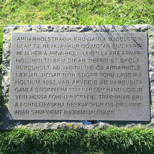
This small, unassuming stone plaque is located on Arnarhóll which overlooks the port and old downtown areas of Reykjavik. It talks about a pathway that connected central Reykjavik (what is now "Old Town") to outlying farms like Arnarhóll and those on Arnarhólsholti (now called Skólavörðuholt, the large hill that is home to the large church, Hallgrimskirkja. the plaque reads:
"Arnarhólstranðir eru gamla þjóðleiðin ofan til Reykjavíkur og mótar enn fyrir þeim hér á Arnarhóli. Leiðin lá frá Arnarhólsholti, sem síðar nefndist skólavörðuholt, að vaðinu við ós Arnarshólslækjar. Þegar nýir stígar voru lagðir á hólnum 1993 var ákveðið að varðveita gamla stíginn frá 1924 þar sem hann liggur yfir þessa fornu þjóleið. Traðirnar eru á fornleifaskrá Reykjavíkur og eru friðaðar samkvæmt þjóðminjalögum."
"Arnarhól Beach is the old main route to the east in and out of Reykjavik and made for those living at Arnarholl farm. The road went from Arnarholl’s Hill, which was later called Skólavörðuholt, to the ford at the mouth of Arnarshóll Creek (long since covered up, the Creek once connected the Pond to the bay). When new paths were constructed in 1992, it was decided to preserve the old path from 1924, which was constructed over the ancient path. The route is the list of antiquities of Reykjavik, and is protected."
The old path runs along what is now Hafnarstræt. A More informative sign can be found here:https://s3.amazonaws.com/gs-waymarking-images/a24e7f10-3696-4bb1-ae10-ac0169a19dec.jpg