

Ballyscullion Church

The tablet on the wall of the church contains what looks like, to my untutored eye, a bit of Greek text. The date on the tablet is AD 1847 though it's hard to make out. © Copyright Robert...
- village
- rural settlement
- religious sites
- geograph
George Elmy Lifeboat Way
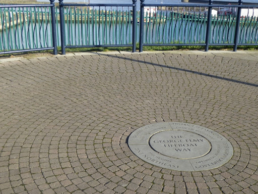
The George Elmy Lifeboat Way is the name given in 2013 to the new Top Dock Road in Seaham. It commemorates the lifeboat "George Elmy" which was involved in a disastrous rescue bid in 1962...
- paths
- footway
- railings
- geograph
- historic sit...
- long distanc...
- path
- roads
- road transport
- road
Poem, illustrations and information plaques at Nose's Point

Accompanying the information plaques and illustrations is a poem in the form of a "mesostic" made from a name, by Alec Finlay and Thomas A Clark. Taken togther, the poem reads: "staNd upOn...
- poem
- educational sites
- information panels
- geograph
- plaques
Friars Walk official opening plaque, Newport
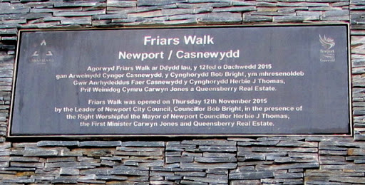
High up on the wall at the edge of these steps, Link the plaque records the official opening of Friars Walk on Thursday November 12th 2015. The text is also in Welsh. © Copyright Jaggery...
- public build...
- bilingual
- geograph
Information plaque

Relating to the disused meeting house. © Copyright Robert Ashby and licensed for reuse under this Creative Commons Licence . Submitted via Geograph
- village
- rural settlement
- religious sites
- geograph
Start of the Pennine Way

This plaque is set into a wall just west of the Old Nags Head. Simultaneously inspiring and daunting. © Copyright Dave Dunford and licensed for reuse under this Creative Commons Licence...
- paths
- edale
- geograph
- sport
- leisure
- pennine way
Plaque at the former Eastbourne Fire Station

© Copyright Ian S and licensed for reuse under this Creative Commons Licence . Submitted via Geograph
- city
- town centre
- former fire station
- public build...
- geograph
Plaque at top of Kinnoull Hill

The plaque describes the prospect from Kinnoull Hill. Presented by John I Anderson Esq., Langfauld, Glenfarg, Perthshire, 1949. © Copyright Richard Sutcliffe and licensed for reuse under this...
- quarrying
- mining
- geograph
Warminster Obelisk information

A plaque on the base of the obelisk ST8645 : The Obelisk at Warminster. © Copyright M J Richardson and licensed for reuse under this Creative Commons Licence . Submitted via Geograph
- village
- rural settlement
- lowlands
- wiltshire
- people
- events
- land enclosure
- 1783
- warminster
- geograph
- obelisk
- historic sit...
Coptic Church Opening Plaque
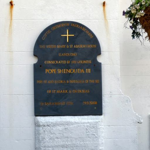
The plaque on the front of the church SH7881 : The Virgin Mary And Saint Abaskhyroun reads: COPTIC ORTHODOX PATRIARCHATE THE VIRGIN MARY & SAINT ABASKHYROUN LLANDUDNO CONSECRATED BY HIS...
- coptic church
- religious sites
- geograph
- 2008
- pope shenouda iii
Plaque on Stroud Brewery Bridge

Clay plaque on Stroud Brewery Bridge which was constructed in 2011 and crosses the Stroudwater canal. © Copyright Philip Halling and licensed for reuse under this Creative Commons Licence...
- canals
- geograph
Plaque

Plaque to the mass grave of half the population of Inver, who died of the cholera epidemic of 1832. © Copyright valenta and licensed for reuse under this Creative Commons Licence . Submitted via Geograph
- estuary
- marine
- historic sit...
- coastal
- geograph
Date plaque on the Brunswick station ramp

This plaque records that the ramp, horse trough and urinals were built by the Health Committee in 1866. The ramp and steps used to provide access to a bridge across the railway lines, but the...
- railways
- ramp
- geograph
- historic sit...
- roads
- road transport
Plaque at Brunswick New Station

This plaque commemorates the opening of Brunswick New Railway Station on 26th March 1998. © Copyright John S Turner and licensed for reuse under this Creative Commons Licence . Submitted via Geograph
- railways
- railway station
- geograph
Wildlife Garden Opened By:

© Copyright Billy McCrorie and licensed for reuse under this Creative Commons Licence . Submitted via Geograph
- country estates
- geograph
Wildlife Garden, Culzean Country Park

© Copyright Billy McCrorie and licensed for reuse under this Creative Commons Licence . Submitted via Geograph
- country estates
- geograph
Wildlife Garden, Culzean Country Park

© Copyright Billy McCrorie and licensed for reuse under this Creative Commons Licence . Submitted via Geograph
- country estates
- geograph
'Rehoboth 1911' plaque on The Salvation Army church

This plaque is high up on the front of what is now The Salvation Army church in Dee Road, Connah's Quay - Link Originally the building was the Rehoboth Congregational Chapel. See also SJ2969 : The...
- salvation ar...
- religious sites
- geograph
- date plaque
Irvine Burns Club cairn

The cairn is beside the A78 and carries a plaque NS3339 : Drunken Steps plaque, which was resited by the road builders. "This cairn was erected for Irvine Burns Club to mark their 150th...
- cairn
- suburb
- urban fringe
- geograph
Paradise in hiding

'Paradise Row' is a fine collection of houses in Woollard that were for mill workers. Woollard dates from possibly Saxon times, but was certainly part of the (Norman) Hungerford estate. The...
- village
- rural settlement
- geograph
- housing
- dwellings
- workers cottages
- street name sign
- historic sit...