

Lincoln Under Fire

From the Flickr group Historical Markers, photo by AlbinoFlea, full page.License is Attribution- NonCommercial License
Eira in September

From the Flickr group Historical Markers, photo by hugovk, full page.License is Attribution- NonCommercial-ShareAlike License
Church was Robbed March 1840

From the Flickr group Historical Markers, photo by hugovk, full page.License is Attribution- NonCommercial-ShareAlike License
1836 stocks sign

From the Flickr group Historical Markers, photo by hugovk, full page.License is Attribution- NonCommercial-ShareAlike License
Fort DeRussy

From the Flickr group Historical Markers, photo by AlbinoFlea, full page.License is Attribution- NonCommercial License
Dumbarton House Plaque

From the Flickr group Historical Markers, photo by AlbinoFlea, full page.License is Attribution- NonCommercial License
Peirce Mill

From the Flickr group Historical Markers, photo by AlbinoFlea, full page.License is Attribution- NonCommercial License
Kutz Bridge Plaque

From the Flickr group Historical Markers, photo by AlbinoFlea, full page.License is Attribution- NonCommercial License
Commemorative Plaque on Exterior of the Barney Studio House/Embassy of Latvia

From the Flickr group Historical Markers, photo by AlbinoFlea, full page.License is Attribution- NonCommercial License
Sir Sandford Fleming

From the Flickr group Historical Markers, photo by duncan, full page.License is Attribution- NonCommercial License
Shetland Bus

From the Flickr group Historical Markers, photo by duncan, full page.License is Attribution- NonCommercial License
Routon Mounds

Routon has 7 mounds on the west bank of the Ouachita River. The 4 largest are rectangular with flat tops. The other 3 are dome shaped and less than 2 feet tall. The mound visible from the road is...
Fort Beauregard

One-half mile west was one of four forts built by Confederates in May, 1863 to prevent the ascent of Federal gunboats on the Ouachita River. It was abandoned 1863, but was reoccupied in 1864.
- louisiana
- civil war
McGuffee Mounds

McGuffee has as many as 6 mounds on the west bank of the Ouachita River. Several of the mounds are well preserved and visible from the road. A C-shaped earthen ridge encloses the...
- louisiana
- native american
Tew Lake Mounds

Tew Lake has 3 small, irregularly shaped mounds. The 2 in pasture on the south side of Routon Road are almost 4 feet tall. The one north of Routon Road has been reduced in height by plowing and...
- louisiana
- native american
Troyville Earthworks (#2)

An earthen wall and 9 mounds were once a prominent part of the landscape here. Early explorers described the largest mound or "Great Mound" as being 82 feet high, the tallest mound known in...
- louisiana
- native american
Troyville Earthworks (#1)

The 82-foot-tall "Great Mound" of Troyville once stood here. In 1936, Archaeologist Winslow Walker made this diagram, depicting the size and shape of the mound. Today, only 3 feet of mound fill remains.
- louisiana
- native american
DePrato Mounds

DePrato has 5 dome-shaped mounds, 3 of which are clearly seen from the road. Flooding has covered the ground and lower portions of the mounds with 2½ feet of sediment. Thus, the mounds...
- louisiana
- native american
Wirt Adams's Raid

On December 1, 1863, Confederate Brig. Gen. Wirt Adams moved his cavalry from Gallatin to retake Natchez. Finding the city heavily fortified with Union infantry and heavy artillery, Adams...
- mississippi
- civil war
Jerry Lee Lewis
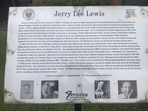
Jerry Lee Lewis, aka The Killer, was born in 1935, in Ferriday, LA, where he began playing piano in his youth with his cousins, Mickey Gilley and Jimmy Swaggart. He grew up listening to...
- louisiana
- music