

Plaque on the Library

Detail of a plaque on the Library which was originally the British School. The context of the building is shown in NZ5610 : High Street, Great Ayton, looking east. © Copyright Christopher Hall and...
- village
- rural settlement
- geograph
Memorial Plaque, Southampton

Located on the city walls walk. The plaque commemorates the repatriation of Far East prisoners of war, and the vessels used to return them to Southampton. © Copyright Peter Trimming and licensed...
- southampton
- people
- events
- geograph
- hampshire
- city
- town centre
- historic sit...
QE2 Anchor Plaque, Southampton

Plaque, outlining the QE2 history. SU4211 : QE2 Anchor, Southampton © Copyright Peter Trimming and licensed for reuse under this Creative Commons Licence . Submitted via Geograph
- southampton
- city
- town centre
- hampshire
- geograph
Holyrood Church, Southampton
Holyrood Church (or Holy Rood Church) was one of the original five churches serving the old walled town of Southampton. Built in 1320, the church was destroyed by bombing, during the blitz, on...
- southampton
- religious sites
- geograph
- hampshire
- city
- town centre
- church (former)
Holyrood Church, Southampton

Holyrood Church (or Holy Rood Church) was one of the original five churches serving the old walled town of Southampton. Built in 1320, the church was destroyed by bombing, during the blitz, on...
- southampton
- religious sites
- geograph
- hampshire
- city
- town centre
- church (former)
Pithead baths plaque

Miners Welfare Fund plaque at the former Caphouse Colliery pithead baths Link now the National Coal Mining Museum Link © Copyright Richard Croft and licensed for reuse under this Creative...
- former coal mine
- pithead baths
- geograph
- mining museum
- quarrying
- mining
- historic sit...
- museum
David Manson plaque, Belfast
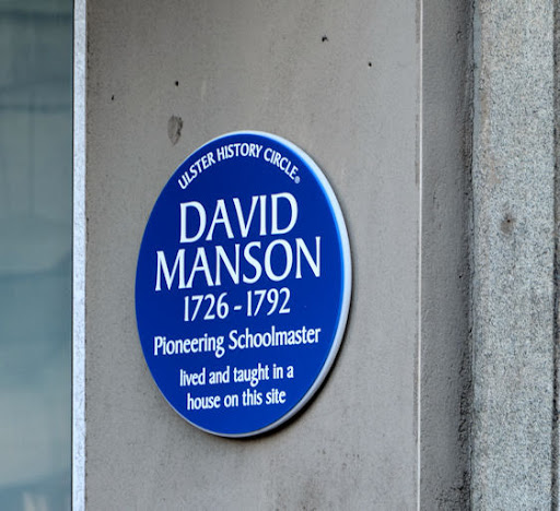
A plaque at the entrance to the Premier Inn J3374 : New hotel, Belfast, at the corner of Donegall Street and Waring Street, commemorating David Manson Link and Link. © Copyright Albert Bridge and...
- belfast
- people
- events
- hotel
- geograph
- city
- town centre
- blue plaque
Sixty-one years ago

The wet winter of 2013/14 with its frequent tidal surges and high river flows caused the Thames Barrier to be shut several times. This is one such occasion, on the early February spring...
- flood defence
- geograph
- thames barrier
- thames
- rivers
- streams
- drainage
To commemorate the opening of the Conwy Tunnel

© Copyright Ian S and licensed for reuse under this Creative Commons Licence . Submitted via Geograph
- paths
- estuary
- marine
- geograph
- north wales ...
- rivers
- streams
- drainage
Zennor: plaque of benefaction on Zennor Head

This plaque is affixed to SW4439 : Zennor: interesting rocks on Zennor Head and, anonymous save for the initials A.B., details the gift of the headland to the National Trust: ZENNOR HEADLAND given...
- rocks
- scree
- cliffs
- outcrop
- geograph
- rocks
- headland
- national trust
Plaque by Kylerhea River footbridge

Detail of a plaque screwed to a small cairn at the side of a wooden footbridge over the Kylerhea River. The plaque reads: 'Constructed By 108 (Welsh) Field Squadron Royal Monmouthshire...
- paths
- geograph
- kylerhea
- footbridge
Poole: D-Day plaque on the Custom House

The plaque, on the side of SZ0090 : Poole: the Custom House facing the quay, states: "On 5th June 1944 over 300 craft left the quays of Poole for the Normandy landings." This sentence is...
- defence
- military
- custom house
- geograph
- docks
- harbours
- city
- town centre
A plaque to Stuart Gilson
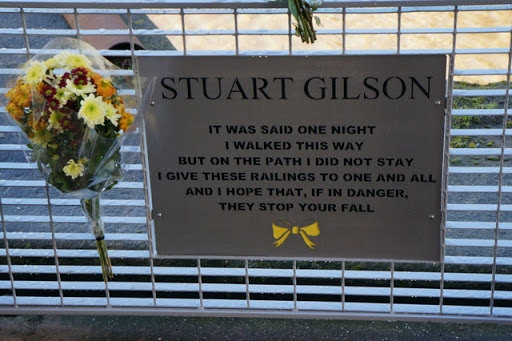
Link © Copyright Ian S and licensed for reuse under this Creative Commons Licence . Submitted via Geograph
- city
- town centre
- rivers
- streams
- drainage
- geograph
Bristol Arms plaque

Plaque in Bristol Arcade Link on the site of the Bristol Arms Hotel (formerly The Angel Inn until 1827), Charles Smith was the proprietor in the late 19th century. © Copyright Richard Croft...
- city
- town centre
- historic sit...
- geograph
Plaque on New Cut Bridge, Swansea

The plaque records the opening of the bridge in 1965, when Swansea, now a city and county, was a county borough. Another plaque nearby Link records details of the bridge it replaced. ©...
- roads
- road transport
- geograph
Plaque from a former bridge across the River Tawe in Swansea

Located near the eastern end of New Cut Bridge which opened in 1965. The small plaque at the bottom records that the plaque above it (dated 1897) is from the fourth bridge spanning the River Tawe...
- historic sit...
- geograph
Windsor Great Park: planted about 1820

A small plaque identifies the age of a tree by the track through the deer park. © Copyright Chris Downer and licensed for reuse under this Creative Commons Licence . Submitted via Geograph
- woodland
- forest
- park and pub...
- tree
- geograph
Plaque for the Cropley monument

The plaque records the monument's restoration in 2005. For context, see TQ1774 : St Mary Magdalene church - Cropley monument. © Copyright Stephen Craven and licensed for reuse under this...
- religious sites
- geograph
- burial ground
- crematorium
- 2005
Queen Elizabeth Field Plaque

A Diamond Jubilee commemoration at the entrance to the Braidburn Valley Park. © Copyright M J Richardson and licensed for reuse under this Creative Commons Licence . Submitted via Geograph
- lowlands
- edinburgh
- braidburn va...
- people
- events
- park and pub...
- queen elizab...
- diamond jubilee 2012
- geograph
- suburb
- urban fringe