

Grady County

This County, created by Act of the Legislature Aug. 17, 1905, is named for Henry W. Grady, nationally famous editor and ´silver tongued orator´ of the New South. Born in Athens, Ga., in 1850 and...
- lat34
Blue Star Memorial Highway

Blue Star Memorial A tribute to the Armed Forces That have defended the United States of America Sponsored by Hillhouse Garden Club of the Laurel District In cooperation with The Garden Club...
- lat34
Blue Star Memorial Highway
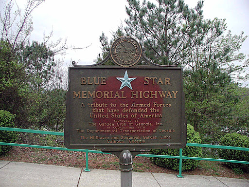
A tribute to the Armed Forces that have defended the United States of America Sponsored by The Garden Club of Georgia, Inc. In cooperation with The Department of Transportation of Georgia and The...
- lat34
Historic Liberty Cumberland Presbyterian Church

Historic Liberty Cumberland Presbyterian Church Erected 1860 Circuit Riders 1847-1853 Formally Established 10 October 1853 1st Painted Church in Northwest Georgia Only church where Union...
- lat34
Atlanta Campaign Resaca May 13-15, 1864

National Historic Site Atlanta Campaign Resaca May 13-15, 1864 IN THIS VICINITY The Confederate lines North and West of Resaca held firm against federal attack. Sherman then executed a successful...
- lat34
Battle of Resaca
![May 13, 1864, McPherson´s 15th and 16th A.C. [USA] moving from Snake Creek Gap reached this cross-roads where his forces were deployed for advance toward Camp Cr. Gen Juson Kilpatrick´s Cav. Div....](http://lh3.googleusercontent.com/ttm9mYWp5hmsAGTQTVVQAvypcprElG3UEAB1pemS7F_E9-hR14Wwb623Zg-32a5cxJmLsuH8Vj01SFNfZVrjuBzDQ7F_)
May 13, 1864, McPherson´s 15th and 16th A.C. [USA] moving from Snake Creek Gap reached this cross- roads where his forces were deployed for advance toward Camp Cr. Gen Juson Kilpatrick´s Cav....
- lat34
Snake Creek Gap
![May 8, 1864. McPherson´s 15th and 16th Corps [USA] seized Snake Creek Gap. On the 9th, attempting to destroy the R. R. at Resaca (defended by Cantey´s Div. of Polks Corps), [CSA] McPherson was...](http://lh3.googleusercontent.com/o5f-ZICTUcC2rN0VEG4wVG3WokRibaiAVRwy9zGIrPSjlaoRvIkPfFZDV85pL0H-DwMIzs8dVLyjcPM9cy46DNsXMuAT)
May 8, 1864. McPherson´s 15th and 16th Corps [USA] seized Snake Creek Gap. On the 9th, attempting to destroy the R. R. at Resaca (defended by Cantey´s Div. of Polks Corps), [CSA] McPherson was...
- lat34
Battle of Resaca May 14, 1864

May 14, 1864 The Battle of Resaca was one of the few places where the entire armies of Sherman and Johnston faced each other in the Atlanta Campaign. Judah´s (2nd) Div., 23rd Army Corps & part of...
- lat34
Battle of Resaca May 14, 1864
![May 14, 1864. A portion of Hood´s A. C., [CSA] thrust forward to hold ridge in fork of cr. was driven back to hills this side of the valley & N. of the road. Cox´s ( 3d ) Div., 23d A. C. [USA]...](http://lh3.googleusercontent.com/TEMWIrLLB3wKIFiMwQm9jS3_dzOUqzHDTrdeSlfoOau_naeQnysah6npekDNcctS96brCO6svOyR1Ku4tiJTyiKFhDQ)
May 14, 1864. A portion of Hood´s A. C., [CSA] thrust forward to hold ridge in fork of cr. was driven back to hills this side of the valley & N. of the road. Cox´s ( 3d ) Div., 23d A. C....
- lat34
Battle of Resaca
![Hood´s line [CSA] beginning E. at State R.R. ran W. to point atop ridge (S) where Hardee´s rt. joined it & together with Polk´s Corps, [CSA] the line was prolonged 3 miles S. to the Oostanaula...](http://lh3.googleusercontent.com/nFEqDoxk3qidVv7TL9powwLHDAYKlGsh2YAeqD5jz4p9f64eGTtFOxEdfLIYi7-XbTFtXXM-QOINUaY_Uqkx71sV7O8)
Hood´s line [CSA] beginning E. at State R.R. ran W. to point atop ridge (S) where Hardee´s rt. joined it & together with Polk´s Corps, [CSA] the line was prolonged 3 miles S. to the...
- lat34
Battle of Resaca May 14-15, 1864
![MAY 14~15, 1864 At this point the intrenched line of Gen. John B. Hood´s Corp´s [CSA] crossed the road ~ this corps being one of the three composing Gen. J.E. Johnston´s Army of Tennessee. Line...](http://lh3.googleusercontent.com/Tf0RhTHi85mKVmN4851XxEg_j_AHFhE-RhpWywIu9-nWUOHCMLfmrL-AsCv5dPlNkjQQPWFedUdKD_PwUIH2oeQmfA)
MAY 14~15, 1864 At this point the intrenched line of Gen. John B. Hood´s Corp´s [CSA] crossed the road ~ this corps being one of the three composing Gen. J.E. Johnston´s Army of Tennessee. Line...
- lat34
Roland Hays JUNE 3, 1867-JANUARY 1, 1977

Roland Hayes, the first internationally removed African - American classical singer was born in Gordon County and performed at this site, the former Calhoun High Auditorium. Hayes opened doors for...
- lat34
Trail of Tears

The New Echota Treaty of 1835 relinquished Cherokee Indian claims to lands east of the Mississippi River. The majority of the Cherokee people considered the treaty fraudulent and refused to leave...
- lat34
Cherokee Nation

During the early 1800´s, northern Georgia was heart of the sovereign, independent Cherokee Indian Nation. By this time Cherokee were the most progressive Indian tribe in North America in...
- lat34
New Echota Ferry
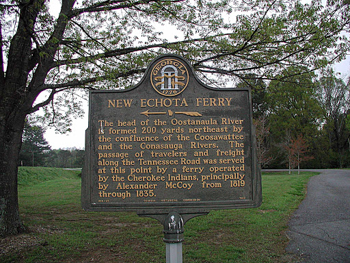
The head of the Oostanaula River is formed 200 yards from northeast by the confluence of the Coosawatte and the Conasauga Rivers. The passage of travelers and freight along the Tennssee Road was...
- lat34
New Echota Cemetery
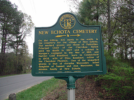
On the hilltop, 100 yards to the south, is the cemetery for the village of new Echota. The marked graves are those of Pathkiller, Principal chief of the Cherokee Nation until his death in 1827 and...
- lat34
Battle of Resaca May 14-15, 1864
![MAY 14-15 1864 0.5 mi W. is Camp Creek Valley, scene of the 23rd Corps [USA] assaults on Hood´s left and Hardee right [CSA], May 14. On ridge 0.2 mi. W. was the position of Wood´s (3rd) Div., 4th...](http://lh3.googleusercontent.com/9QvlqHeC3dOZ3CTAI1Mev-n1dpiugiZZaj8e5DljZp_24tsyZiVpzsmhtkKwzh9z7ZHalSBJ0H8MDJjehvw_Qs8_nGxz)
MAY 14-15 1864 0.5 mi W. is Camp Creek Valley, scene of the 23rd Corps [USA] assaults on Hood´s left and Hardee right [CSA], May 14. On ridge 0.2 mi. W. was the position of Wood´s (3rd) Div.,...
- lat34
New Echota Cherokee National Capital

The sprawling town of New Town which had Stood here since 1819 was designated the seat Of government for the Cherokee Nation in A legislative act of 1825 and it was renamed New Echota for a former...
- lat34
Oothcaloga Mission

The two-story portion of this house was the Oothcaloga Moravian Mission Station, serving this region of the Cherokee Nation from 1822 until 1833.John Gambold, whose grave lies 100 yards east was...
- lat34
Old Sonora P.O. Now Sonoraville
![Maj. Gen. J. D. Cox´s (3d) Div., 23d A. C. [USA] marching S. from Field´s Mill, Coosawattee River, via Cash, took the direct rd. to Sonora. Moving S. 4 mi., the div. turned W. on the Fairmount -...](http://lh3.googleusercontent.com/Inj-t8sU9CHLVNO3_S2Z8Y0NRil8ZZijcpAn1P06iYPRYoFmPsoHkUSzNgkuRyrbNyaw6gvlB4u2Fco5VcK0KEawaCkMcw)
Maj. Gen. J. D. Cox´s (3d) Div., 23d A. C. [USA] marching S. from Field´s Mill, Coosawattee River, via Cash, took the direct rd. to Sonora. Moving S. 4 mi., the div. turned W. on the Fairmount...
- lat34