
CONNIE M. GUION 1882-1971

Pioneer female physician. Gained national reputation from work at Cornell medical clinic, 1922-1970. Born 2/10 mile N.Plaque via North Carolina Highway Historical Marker Program, and is used with...
- ncmarkers
- north carolina
BRITTAIN CHURCH

Presbyterian, organized 1768. Present building, the third, erected 1852, brick-veneered 1940.Plaque via North Carolina Highway Historical Marker Program, and is used with their permission. Full...
- ncmarkers
- north carolina
JOSHUA FORMAN
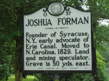
Founder of Syracuse, N.Y., early advocate of Erie Canal. Moved to N. Carolina, 1829. Land and mining speculator. Grave is 50 yds. east.Plaque via North Carolina Highway Historical Marker Program,...
- ncmarkers
- north carolina
THE BLOCK HOUSE

Early landmark, western terminus of the 1772 boundary survey between N.C. and S.C. Stood 1/2 mile east.Plaque via North Carolina Highway Historical Marker Program, and is used with...
- ncmarkers
- north carolina
OAK GROVE

Built 1782. Home of James Johnston, officer in Revolution, member Provincial Congress, legislature, convention of 1788. Is 2 mi. east.Plaque via North Carolina Highway Historical Marker Program,...
- ncmarkers
- north carolina
GILBERT TOWN
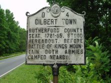
Rutherford County seat, 1781-85, stood hereabout. Before Battle of Kings Mountain both armies camped nearby.Plaque via North Carolina Highway Historical Marker Program, and is used with...
- ncmarkers
- north carolina
CONFEDERATE LABORATORY

Under Dr. A.S. Piggott, manufactured medicine for Confederacy, 1863-65. Remains are 2 mi. S.Plaque via North Carolina Highway Historical Marker Program, and is used with their permission....
- ncmarkers
- north carolina
U. D. C. MEMORIAL HALL
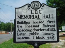
Building housed first the Pleasant Retreat Academy, chartered 1813. Later public library, museum. 1 block east.Plaque via North Carolina Highway Historical Marker Program, and is used with their...
- ncmarkers
- north carolina
WILLIAM CHRONICLE

Major in Revolution, leader of Lincoln County forces at the battle of Kings Mountain, 1780, where he was killed. His home stood nearby.Plaque via North Carolina Highway Historical Marker Program,...
- ncmarkers
- north carolina
GARDNER-WEBB UNIVERSITY

Baptist. Founded 1905 as Boiling Springs High School; junior college, 1928-1971. University since 1993.Plaque via North Carolina Highway Historical Marker Program, and is used with...
- ncmarkers
- north carolina
STONEWALL JACKSON

Thomas J. Jackson, later a Confederate general, married Anna Morrison, July 16, 1857, in her home which stood 200 yds. E.Plaque via North Carolina Highway Historical Marker Program, and is...
- ncmarkers
- north carolina
J. G. ARENDS

Native German, pioneer teacher and minister, ordained 1775, first president of the N.C. Lutheran Synod, 1803. Grave a few yds. east.Plaque via North Carolina Highway Historical Marker Program, and...
- ncmarkers
- north carolina
LENOIR RHYNE

Coeducational, Lutheran college, named for W. W. Lenoir and D. E. Rhyne. Opened as Lenoir College in academic year, 1891-92.Plaque via North Carolina Highway Historical Marker Program, and is used...
- ncmarkers
- north carolina
JOSEPH DICKSON 1745-1825
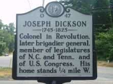
Colonel in Revolution, later brigadier general, member of legislatures of N.C. and Tenn., and of U.S. Congress. His home stands 1/4 mile W.Plaque via North Carolina Highway Historical...
- ncmarkers
- north carolina
CLYDE R. HOEY

United States Senator, 1945-54, congressman, governor, N.C. legislator, lawyer, editor. Home is 1 mi., grave 1.2 mi., N.E.Plaque via North Carolina Highway Historical Marker Program, and is used...
- ncmarkers
- north carolina
CATAWBA SPRINGS

Fashionable "watering place," a recreational and social center prior to 1861. The hotel stood five miles northeast.Plaque via North Carolina Highway Historical Marker Program, and is used with...
- ncmarkers
- north carolina
KINGS MOUNTAIN BATTLEGROUND

Site of decisive British defeat on Oct. 7, 1780. National Military Park located 5 mi. southeast in South Carolina.Plaque via North Carolina Highway Historical Marker Program, and is used with...
- ncmarkers
- north carolina
DALLAS

Named for G.M. Dallas. First seat of Gaston County, 1846-1911; site of Gaston College, now extinct. Courthouse built 1848 is here.Plaque via North Carolina Highway Historical Marker Program, and...
- ncmarkers
- north carolina
CATAWBA COLLEGE

Coeducational, liberal arts. Affiliated with Evangelical & Reformed Church. Opened 1/2 mi. N., 1851. Moved to Salisbury, 1925, & enlarged.Plaque via North Carolina Highway Historical...
- ncmarkers
- north carolina
'OLD BILL' WILLIAMS
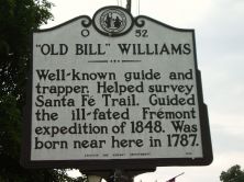
Well-known guide and trapper. Helped survey Santa Fe Trail. Guided the ill-fated Fremont expedition of 1848. Was born near here in 1787.Plaque via North Carolina Highway Historical Marker...
- ncmarkers
- north carolina