Old Town of Rodney - Layout
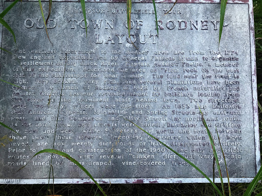
The earliest references to the Rodney area are from the 1774 New England expedition led by General Phineas Lyman to organize a settlement on Big Black River. Captain Matthew Phelps, a member of this expedition, described the area as "firm rock on the east side of the Mississippi for near a mile The land near the river is high, very broken, very rich, and several plantations have been opened." A sketch of Rodney in 1828 by French naturalist and painter Charles Lesueur revealed about 20 buildings leading from the river to the prominent bluff behind town. Two structures were two-story; others were one-story. An 1853 map indicates that Church, Cypress, Magnolia and Spring Streets lay east and west, and Commerce and Olive Streets lay north and south. As the town grew, new streets were added; Batchelor and Griffing lay east and west, while St. Peter lay north and south between these two. These streets, excepting Commerce which has been paved, are now merely dirt roads or have disappeared entirely. Prior to new road construction of the 1960's, the only accessible routes to Rodney were several "sunken" dirt, but very scenic roads lined by moss-draped, vine-covered trees