Michigan Becomes a State
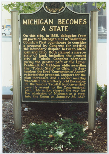
On this site in 1836, delegates from all parts of Michigan met in Washtenaw County’s first courthouse to consider a proposal by Congress for settling the boundary dispute between Michigan and Ohio. Both claimed a narrow strip of land, including the present city of Toledo. Congress proposed giving the greater part of the Upper Peninsula to Michigan while awarding the “Toledo Strip” to Ohio. In September the first “Convention of Assent” rejected this proposal. Support for the plan increased, and a second meeting was called. On a bitterly cold December 14 the famous “Frostbitten Convention” gave its assent to the Congressional plan. This action cleared the way for the admission of Michigan as a state into the Union on January 26, 1837.
Plaque via Michigan History Center