The Right Wing at McDonough
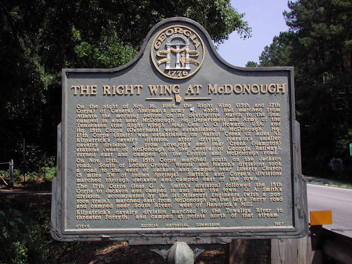
On the night of Nov. 16, 1864, the Right Wing (15th and 17th Corps) of General Sherman´s army (USA), which had marched from Atlanta the morning before on its destructive March to the Sea, camped in and near McDonough. Hq. Department of the Tennessee (the Right Wing), Maj. Gen. O.O. Howard, USA, and Hq. 15th Corps (Osterhaus) were established in McDonough. Hq. 17th Corps (Blair) was established on Walnut Creek (2 miles N), Kilpatrick´s cavalry division, after driving Iverson´s smaller cavalry division (CSA) from Lovejoy´s and Bear Creek (Hampton) stations (west of McDonough on the Central of Georgia Railway), turned east and camped on the Griffin and McDonough Road.
On Nov. 17th, the 15th Corps marched south on the Jackson Road. South of Locust Grove, Wood´s and Hazen´s divisions took a road to the west of Jackson and camped near Liberty Church (3 miles SW of Indian Springs). Smith´s and Corse´s divisions marched through Jackson and camped east of the town.
The 17th Corps (less G.A. Smith´s division) followed the 15th Corps to Jackson and camped in and near the town. G.A. Smith´s division, accompanied by the 1st Missouri Engineers (with a pontoon train), marched east from McDonough on the Key´s Ferry road and camped near South River.., west of Hendricks´s Mill.
Kilpatrick´s cavalry division marched to the Towliga River to threaten Forsyth, and camped at points north of that stream.
GHM 075-5 Georgia Historical Commission 1957
Plaque courtesy Lat34North.com.
Original page, with additional info, here.
Photo credit: Byron Hooks of Lat34North.com.