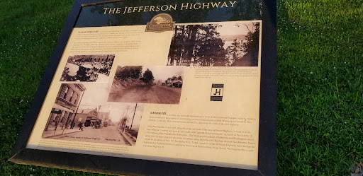
The Jefferson Highway
The Louisiana Purchase of 1803 was the first large step for the United States to complete its calling of Manifest Destiny to expand from sea to shining sea. Though national attention focused on east-west travel it would be another 114 years before a seamless road would traverse from North to South along with President Jefferson's addition of the United States.
The Jefferson Highway Association, named after Thomas Jefferson, was formed in 1915 to build a highway from Winnipeg, Manitoba, Canada to New Orleans, Louisiana, in the United States. The Highway was the idea of Edwin T. Meredith (of Iowa), published of Successful Farming and Better Homes and Gardens and later Secretary of Agriculture under President Woodrow Wilson, who thought the highway would be economically beneficial to the region's farmers.
In November 1915, a meeting was held with representatives from all the Louisiana Purchase states to organize an association for the purpose of constructing an international highway from Winnipeg in Canada to New Orleans, Louisiana. This convention was also held to determine the route of the new highway. Once Natchitoches found itself along the proposed route of the new Jefferson Highway, it went to work improving its "crooked and narrow" dirt roads with "splendid brick pavement" as stated in the October 21, 1915 edition of the Natchitoches Enterprise. The brick-paved portions of Jefferson and Washington streets along with the sections of gravel pavement elsewhere along Jefferson Highway through Natchitoches Parish would be the praise of the 1919 Sociability Run. Today, a portion of the Jefferson Highway runs through the Natchitoches National Historic Landmark District of Jefferson Street, Front Street, Washington Street and Louisiana Highway 6.