The Founding of Stouffville
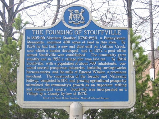
In 1805-06 Abraham Stouffer (1780-1851), a Pennsylvania Mennonite, acquired 160 ha of land in this area. By 1824 he had built a saw and grist-mill on Duffin's Creek, near which a hamlet developed, and in 1832 a post-office named Stouffville was established. The community grew steadily and in 1852 a village plot was laid out. By 1864 Stouffville, with a population of about 700 inhabitants, contained several prosperous industries, including carriage-works, harness-works, and the mills of Edward Wheler, a prominent merchant. The construction of the Toronto and Nipissing Railway, completed in 1871, and growing agricultural prosperity stimulated the community's growth as an important milling and commercial centre. Stouffville was incorporated as a Village by a County by-law of 1876.
Plaque via Alan L. Brown's site Ontario Plaques. Full page here.