Moses Cleveland's "Capital Town"
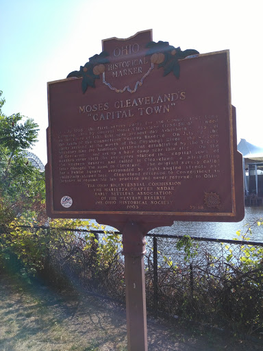
Moses Cleveland's "Capital Town"
In July 1796 the first survey party for the Connecticut Land
Company, led by General Moses Cleveland (1754-1806) landed
on the shore of Lake Erie near present-day Ashtabula to lay out
the lands of the Connecticut Western Reserve. On July 27, the
party arrived at the mouth of the Cuyahoga River, the Western
boundary line for American settlement established by the Treaty
of Greenville, and set up a base camp near this site. On the
eastern river bluff the surveyors platted the capital town of
the Western Reserve and called it "Cleaveland": a misspelling
later changed the name to Cleveland. The original survey called
for a Public Square, surrounded by right angled streets and
uniformly shaped lots. General Cleaveland returned to Connecticut in
October to resume his law practice and never returned to Ohio."
The Ohio Bicentennial Commission
The Marietta Chapter NSDAR
Early Settlers Association of the Western Reserve
The Ohio Historical Society, 2003.
Submitted by: OpenStl