

City of Thibodaux

Incorporated as a town on March 10, 1838. Early records show settlement existed in late 1790's as an important trading post for the Lafourche country. Named for Henri Schuyler...
- louisiana
Leonidas Polk

Born April 10, 1806in RaleighNorth CarolinaDied June 14, 1864at Pine MountainGeorgiaFirst Bishop of Louisiana1841——1864Organized SaintJohn's Church
- louisiana
Nine Dragon Wall

From the Flickr group Historical Markers, photo by Crawford Brian, full page.License is Attribution- NonCommercial-ShareAlike License
Fayette County

Octagon Brewery

From the Flickr group Historical Markers, photo by chrisinplymouth, full page.License is Attribution- NonCommercial-ShareAlike License
San Luis Obispo

From the Flickr group Historical Markers, photo by tkksummers, full page.License is Attribution- ShareAlike License
Rachel Revere Park
From the Flickr group Historical Markers, photo by Jason Riedy, full page.License is Attribution License
John Newberry's Marker

From the Flickr group Historical Markers, photo by Gerry Dincher, full page.License is Attribution- ShareAlike License
Plaque

From the Flickr group Historical Markers, photo by chrisinplymouth, full page.License is Attribution- NonCommercial-ShareAlike License
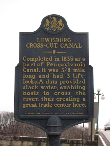
Lewisburg Cross-Cut Canal historic marker
From the Flickr group Historical Markers, photo by Gerry Dincher, full page.License is Attribution- ShareAlike License
Elwell Ferry

From the Flickr group Historical Markers, photo by Lesley Looper, full page.License is Attribution- NonCommercial License
Old Dearborn Bank Building

From the Flickr group Historical Markers, photo by Crawford Brian, full page.License is Attribution- NonCommercial-ShareAlike License
Jersey Settlers
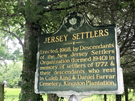
Erected, 1968, by Descendants of the New Jersey Settlers Organization (formed 1940) in memory of settlers of 1772 & their descendants who rest in Caleb King & Daniel Farrar Cemetery, Kingston Plantation.
- missisippi
Metairie Ridge School

On this site in April 1909, the first public school in Metairie opened and Metairie Ridge School. Land donated by Alfred E. Bonnabel who is often referred to as "The Father of Education"...
- louisiana
- education
Peck Village

Peck Village is a village and mound site where Indians lived between 100 BC and AD 1200. Archaeologist James A. Ford excavated here in 1933. He used a method called seriation to study the changes...
- louisiana
- native american
Peck Mounds
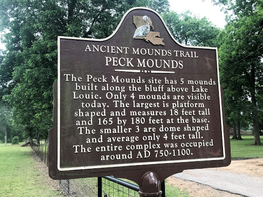
The Peck Mounds site has 5 mounds built along the bluff above Lake Louie. Only 4 mounds are visible today. The largest is platform shaped and measures 18 feet tall and 165 by 180 feet at the base....
- louisiana
- native american
Harrisonburg Mounds

Two Indian mounds make up the Harrisonburg Mounds site. The well-preserved conical mound that can be seen from here was built around AD 200. It is 10 feet high and 115 feet in diameter. The...
- louisiana
- native american
Lamarque Landing Mound

Lamarque Landing is a conical mound that is 6½ feet tall and 115 feet in diameter. Indians built the mound about AD 1000. Excavations at the site revealed that the mound was built in 3 separate episodes.
- louisiana
- native american
Cypress Grove Mound

Cypress Grove is one of the best-preserved conical mounds in northeast Louisiana. This 10-foot-tall mound is 115 feet in diameter at the base. It was built in a single episode around AD 750. The...
- louisiana
- native american
Jersey Settlers

Erected, 1968, by Descendants of the New Jersey Settlers Organization (formed 1940) in memory of settlers of 1772, including Captain Amos Ogden. The Swayzes, Thorns & others now rest in...
- mississippi