
Plaque at Redgrave Cricket Ground

Off Churchway near Redgrave Activities Centre © Copyright Adrian Cable and licensed for reuse under this Creative Commons Licence . Submitted via Geograph
- village
- rural settlement
- redgrave
- activities centre
- geograph
- sport
- leisure
- closeup
- redgrave act...
- churchway
- redgrave cri...
- cricket ground
Audley: Millennium Green (plaque)

© Copyright Jonathan Hutchins and licensed for reuse under this Creative Commons Licence . Submitted via Geograph
- village
- rural settlement
- audley
- millennium green
- park and pub...
- geograph
- historic sit...
- castle motte
Joseph Wood Memorial Plaque
![Plaque on the wall of the former Joseph Wood Memorial Sunday School SJ8079 : Former Sunday School Buildings, Knutsford Road]. Dated 1901. © Copyright David Dixon and licensed for reuse under this...](http://lh3.googleusercontent.com/Hd2y4VeTfAkxOwdh26OT-yqpVBVVWkK_HI0u2HYht6jing9AZo7c8BBVssp9_ztlagYSeS2HQcawdDz71u8XL8vWYcBy)
Plaque on the wall of the former Joseph Wood Memorial Sunday School SJ8079 : Former Sunday School Buildings, Knutsford Road]. Dated 1901. © Copyright David Dixon and licensed for reuse under this...
- village
- rural settlement
- panasonic lumix tz60
- religious sites
- geograph
- historic sit...
- 1901
- former sunday school
Plaque on The Meeting House, 27 St. Helen's Street, NE45

See NY9864 : The Meeting House, 27 St. Helen's Street, NE45. © Copyright Mike Quinn and licensed for reuse under this Creative Commons Licence . Submitted via Geograph
- village
- rural settlement
- housing
- dwellings
- religious sites
- geograph
- historic sit...
Commemorative plaque to Raymond Mays at Bourne, Lincolnshire
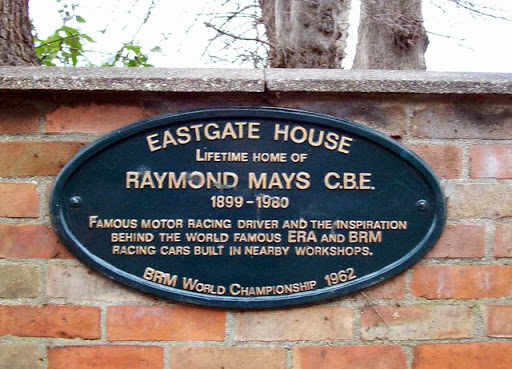
A cast iron plaque commemorating the life of the international racing driver and BRM designer Raymond Mays (1899-1980) erected on the wall outside the house in Eastgate where he was born was...
- housing
- dwellings
- people
- events
- geograph
- sport
- leisure
- suburb
- urban fringe
King's Head plaque

National Trust plaque in King's Head yard Link © Copyright Richard Croft and licensed for reuse under this Creative Commons Licence . Submitted via Geograph
- historic inn
- geograph
- national tru...
- historic sit...
- grade ii(sta...
Blue plaque for Charles Worth at Bourne, Lincolnshire

A prestigious blue plaque issued by English Heritage can be seen on the front of Wake House in North Street to mark the birth of Charles Worth (1825-95), son of a local solicitor, who left to seek...
- people
- events
- city
- town centre
- public build...
- geograph
Plaque on Blakemoor Bridge

The bridge spans the outflow from Cresswell Pond. The plaque reads: In December 1996 Ready Mixed Concrete ceased sand extraction from the beach here after negotiations with Northumberland...
- geograph
- roads
- road transport
- coastal
- road bridge ...
Plaque on former police station

The plaque explains that this house SO8454 : Former police station, Copenhagen Street, Worcester was the Worcester City Police Station from 1862 to 1941. © Copyright Stephen Craven and licensed...
- city
- town centre
- geograph
Information plaque, Carew Cross

© Copyright Jo Turner and licensed for reuse under this Creative Commons Licence . Submitted via Geograph
- village
- rural settlement
- religious sites
- historic sit...
- geograph
Queen's Jubilee Garden on New Road, Hedon
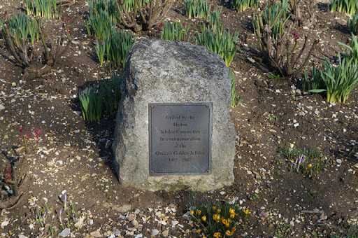
© Copyright Ian S and licensed for reuse under this Creative Commons Licence . Submitted via Geograph
- city
- town centre
- park and pub...
- geograph
Shere: St James' Church, Church Lane

A plaque erected on the wall next to the war memorial. © Copyright Michael Garlick and licensed for reuse under this Creative Commons Licence . Submitted via Geograph
- village
- rural settlement
- people
- events
- geograph
Plaque on the old Corn Hall, Swaffham
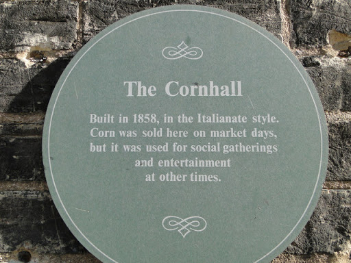
© Copyright Adrian S Pye and licensed for reuse under this Creative Commons Licence . Submitted via Geograph
- city
- town centre
- geograph
Sundial plaque, Horniman Museum

On the conservatory TQ3473 : Conservatory, Horniman Museum. (below the sundial TQ3473 : Sundial, Horniman Museum). Since the Earth's orbit is elliptical and its axis of rotation is...
- conservatory
- geograph
- historic sit...
- horniman mus...
- sundial
Dated plaque, Dyan Orange Hall

Pictured here H7649 : Dyan Orange Hall © Copyright Kenneth Allen and licensed for reuse under this Creative Commons Licence . Submitted via Geograph
- public build...
- geograph
Plaque on the Swing Bridge

See NZ2563 : The Swing Bridge. © Copyright Mike Quinn and licensed for reuse under this Creative Commons Licence . Submitted via Geograph
- city
- town centre
- roads
- road transport
- rivers
- streams
- drainage
- geograph
Plaque, Alston Arches Viaduct

Red plaque erected at Transport Heritage Sites by Transport Trust. Link © Copyright Andrew Curtis and licensed for reuse under this Creative Commons Licence . Submitted via Geograph
- uplands
- railways
- geograph
- suburb
- urban fringe
- derelict
- disused
- rivers
- streams
- drainage
Information tablet

Stone tablet, possible originally on the school wall, marks the location where the school once stood, now the carpark of the First Ballyeaston Presbyterian Church Hall. A bit more...
- educational sites
- geograph
Plaque at the Forest Road Bridge

SK4313 : Forest Road footbridge © Copyright Mat Fascione and licensed for reuse under this Creative Commons Licence . Submitted via Geograph
- footbridge
- city
- town centre
- geograph
Plaque at Barton Ropery, Barton upon Humber

© Copyright Ian S and licensed for reuse under this Creative Commons Licence . Submitted via Geograph
- village
- rural settlement
- geograph
- historic sit...
- former ropery