
For Scurvy Ridden Whale Men

MRS HUMPHREY'S HOUSE TEMPORARY HOSPITAL1835 - 1836 FOR SCURVY RIDDEN WHALE MEN WHO HAD BEEN TRAPPED IN THE ICE FOR MONTHS Submitted by @LGThomson1
- scotland
- scurvy
- whale
- months
- ice
Pooh Bear

Found this on the way to a fishing trip at Flindt Landing Camp, ON, Canada (50°14'45.4"N 90°26'41.1"W). On the way through White Water we stopped for gas. I saw a familiar statue that I had to...
Was Perceived to have Lived and Died Here

Photographed by Arenamontanus Attribution 2.0 Generic
- oxford
- england
- berkeley
- george berkeley
- philosophy
Mary and Gene Tarrant

More info at Berkeleyside.
- berkeley
- california
- cal
- bay area
- edwards
- tarrant
Japantown Peace Pagoda

この平和の塔は 日本の人々から 友情のしるしとして アメリアの人々に おくられたものです。 昭和四十三年青二十八日 一九六八年 The Peace Pagoda Presented in friendship to the people of The United States by the people of Japan March 28,1968
- san francisco
- japantown
- japanese
- california
- bay area
In Memory of Charles M. Toole

In Memory of Charles M. Toole Killed in Action Cierges, France October 1, 1918 Submitted by @mywolfson
Bethel Church

Submitted by @alwaysreadtheplaque.
Bayou Sara

Submitted by @alwaysreadtheplaque.
Hoping to Join the Few

Submitted by Linda Nutman.
- south carolina
- fort mill
- civil war
- confederacy
Vestal's Gap Road

VESTAL'S GAP ROAD Extending from Alexandria to Vestal's Ferry near Charles Town West Virginia, this colonial highway was a principal route from the Northern Neck of Virginia through the Blue Ridge...
- virginia
- herndon
- road
- armies
- settlers
Vestal's Gap Road

Submitted by @jqmcd.
- virginia
- herndon
- trail
- vestal
James Monroe's First Farm

Submitted by @richzukowski via https://m.flickr.co m/#/photos/richzukowski/14686861795/in/search_QM_q _IS_readtheplaque_AND_mt_IS_all_AND_w_IS_all
- charlottesville
- virginia
- jefferson
- monroe
- monticello
- academical village
- plantation
- slavery
- highland
- university
Plaque near St Woolos Cathedral

The location of this plaque can be seen here ST3087 : St Woolos Cathedral and boundary wall. © Copyright Robin Drayton and licensed for reuse under this Creative Commons Licence . Submitted via Geograph
- geograph
Boy Scouts in the Summer of 1910

In the summer of 1910, about two miles south of Hudson on the Wisconsin shore of the St. Croix River, 86 boys and adults held an experimental week of camp to try out a new youth program...
- boy scouts
- wisconsin
Poisson's Landing

Dedicated to the memory of Captain William G. "Bill" Poisson, 1924-2008 The Poisson Family owned and operated a steamboat excursion business and boat livery at this location from 1882 to...
- boat landing
- east grand rapids
- reeds lake
- steamboat
Plaque, Flood Cottages

The plaque records details of the 'Awful Visitation' that happened to Tilshead in 1841. The Flood Cottages were built in 1842 from public fund to help the poor in the Tilshead and...
- village
- rural settlement
- tilshead
- geograph
- flood
- sign
Flood markers at the weir

Flood markers showing the heights of the floods at Buscot Lock © Copyright Bill Nicholls and licensed for reuse under this Creative Commons Licence . Submitted via Geograph
- village
- rural settlement
- geograph
- historic sit...
- flood height...
Flood level marks on a house in Girton
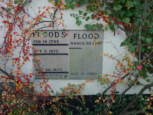
The heights that River Trent floods reached in the village of Girton are marked on a house wall. The house is now known as Mallard Corner but is identified as Sunnyside on old maps. ©...
- village
- rural settlement
- flood
- flood levels
- geograph
Sheldon Grist Mill
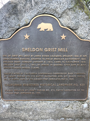
SHELDON GRIST MILL SITE OF GRIST MILL BUILT BY JARED DIXON (JOAQUIN) SHELDON 1846-47 ON OMOCHUMENES RANCHO, GRANTED TO HIM BY THE MEXICAN GOVERNMENT 1843. SHELDON BORN VERMONT JANUARY 8, 1813,...
- sacramento
- california
- miners
- dam
- mill
- omochumnes
- vermont
Destroyed by Fire in 1890 and Rebuilt the Same Year

Submitted by Sheila Paske
- sloughhouse
- california
- sheldon
- consumnes
- stanford
- leland
- fertile
- amador