

Whitesville Methodist Church Cemetery (Side 2)

The adjacent cemetery predates the church building. It has several types of burial markings from the earliest stacked stone and brick graves to metal mail-order grave markers. There are numerous...
- lat34
Whitesville Methodist Episcopal Church, South (Side 1)

The Methodist church in Whitesville had its origins about 1828 in meetings held at the home of Reuben Mobley. The First methodist Church was founded in the early 1830s and by 1837 the decision was...
- lat34
Valley of Hope

Pine Mountain Valley, Georgia was begun in November 1934 under the administration of Franklin D. Roosevelt and his New Deal plan. It was conceived as a pilot community relief project to provide an...
- lat34
Sunnyside School

The community building and spaces in the Sunnyside/Midway Historic District reflect rural Harris County in the 1920´s. Sunnyside School was built by local residents in 1921 to consolidate several...
- lat34
B. F. White 1800-1879

1800-1879 Song writer, teacher, editor, lived in Hamilton, 1843 - c.1868, was mayor, 1865. Near this spot in 1844 he published Sacred Harp, a ´fa- sol-la´ acappella singing school book now in...
- lat34
Franklin D. Roosevelt Memorial Bridge
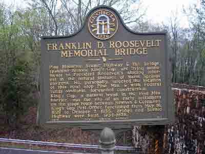
Pine Mountain Scenic highway & this bridge, spanning historic King´s Gap, are living monuments to President Roosevelt´s abiding interest in the natural features of Warm Springs´ environs....
- lat34
This Was His Georgia

Franklin D. Roosevelt was a frequent visitor (41 trips) to Warm Springs from 1924-1945. Dowdell´s Knob was one of his favorite spots for both quiet contemplation and picnics. F.D.R. visited...
- lat34
Dowdell's Knob

The road extending one mile south traverses a spur which projects into Pine Mountain Valley and terminates in a knob 1395 feet elevation above sea level overlooking a spectacular spread of...
- lat34
The Wire Road

This road marks the route of the first telegraph lines from Washington to New Orleans, via Columbus, completed in 1848. The road entered Harris County at Mount Airy (later Ridgeway), 5 miles from...
- lat34
Columbus Baptist Association

The Columbus Baptist Association was organized November 22, 1829 at Mulberry Meeting House (then New Hope). 10 miles from here at Mulberry Grove. Twelve churches reporting from Talbot. Harris,...
- lat34
U.S.S. Harris County

This bell was presented to Harris County by LST 822, U.S.S. HARRIS COUNTY, commissioned Nov. 23, 1944. Carrying the commander of LST Group 68, she led fourteen convoys through enemy waters...
- lat34
Waverly Hall

This town was named by its first postmaster. William Osborne, appointed February 2, 1829. In 1827, Mt. Zion Methodist Church was built 1 ½ miles E. on the Old Indian Trail and Stage-coach Road...
- lat34
Pine Mountain Valley Resettlement Project

The Resettlement Administration was founded on May 1, 1935 as part of the second phase of President Roosevelt´s New Deal. FDR took a personal interest in the planning of this project with...
- lat34
Kingsboro & Cataula

At KINGSBORO. 3mi. S., Ga.´s first narrow gauge railroad (North & South RR), chartered in 1870 (Columbus to Romel), ended in 1873. CATAULA (Big Rock) is a Creek name. Clowers Meth....
- lat34
Whitesville

Incorporated in 1837 and named for the pioneer ´White´ family. Whitesville was the site of a stagecoach stop, inn, and stores on a branch of the Oakfuskee Indian Trail. This early road continued...
- lat34
Bartlett's Ferry Dam: Antioch Baptist Church

BARLETT´S FERRY DAM: ANTIOCH BAPTIST CHURCH --- 1 ½ Miles --> Rev. Simpson Wilson Barley (1827-1884), minister and doctor, operated a ferry, known as Bartley´s Ferry, 1 ½ miles west on the...
- lat34
Harris County

This county, created by Acts of the Legislature Dec. 14 & 24, 1827, is named for Charles Harris, eminent Savannah jurist. Born in England and educated in France, he served Savannah as Alderman or...
- lat34
Blue Star Memorial Highway
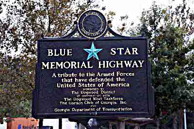
A tribute to the Armed Forces That have defended the United States of America SPONSORED BY The Dogwood District In cooperation with The Dogwood West Taskforce The Garden Club of Georgia, Inc, And...
- lat34
Seven Chestnuts

On this site under seven chestnut trees the Creek Indians held their council meetings. A.J. McBridge Chapter, U.D.C., - 1970 70 Plaque courtesy Lat34North.com. Original page, with additional info,...
- lat34
Sandtown Trail

This road was originally the Sandtown Trail traveled by several tribes of Creek Indians. It connected Sandtown on the chattahoochee river near Atlanta, Ga. with another Sandtown in Tallapoosa Co.,...
- lat34