

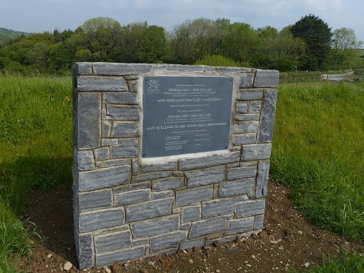
Plaque, Hope Methodist Chapel, Black Torrington

Evidence for the dates given in SS4605 : Hope Methodist Chapel, Black Torrington. The plaque is on the south wall facing the burial ground. © Copyright Derek Harper and licensed for reuse under...
- religious sites
- geograph
- bible christ...
- datestone
- methodist church
- historic sit...
Plaque on Glemsford Village sign

On the B1065 Tye Green at the junction with Water Lane © Copyright Adrian Cable and licensed for reuse under this Creative Commons Licence . Submitted via Geograph
- village
- rural settlement
- road junction
- glemsford vi...
- the junction...
- water lane
- b1065
- glemsford
- geograph
- b1065 tye green
- the b1065 tye green
- closeup
- tye green
- village sign
- sign
Plaque on Burton Bridge

A rather more restrained companion to Link © Copyright Alan Murray-Rust and licensed for reuse under this Creative Commons Licence . Submitted via Geograph
- commemorative plaque
- people
- events
- road over river
- geograph
- city
- town centre
- 1926
- roads
- road transport
Blue plaque on Burton Bridge

Commemorating the storming of Burton via the bridge during the Civil War. © Copyright Alan Murray-Rust and licensed for reuse under this Creative Commons Licence . Submitted via Geograph
- people
- events
- geograph
- english civil war
- blue plaque
Plaque by De Lacey Bridge, Drogheda, Co. Louth

The plaque states that the De Lacey Bridge was unveiled by Councillor Tommy Murphy, Mayor of Drogheda, on Thursday, November 10th, 2005. O0975 : De Lacey Bridge, Drogheda, Co. Louth. © Copyright P...
- paths
- geograph
- footbridge
- city
- town centre
- rivers
- streams
- drainage
Inchcolm Seals plaque

On the stone sculpture by Newhalls Road. © Copyright Stanley Howe and licensed for reuse under this Creative Commons Licence . Submitted via Geograph
- eh30
- geograph
- seals
- stone sculpture
- metal plaque
- south queensferry
- historic sit...
Start of the Black Country

The view of the stone off the Great Bridge Road(A4098) in Bradley, Bilston. Near this spot John Wilkinson (1728-1808) erected his first Black Country Blast Furnace. 1767 It marked the beginning of...
- bilston
- geograph
- former blast furnace
- black country
- streetscene
- historic sit...
Commemorative plaque, Burton Bridge

Erected to commemorate the widening of the bridge in 1925. One wonders whether the inhabitants of Burton were as appreciative as the inscription makes out, or whether this was more a case...
- commemorative plaque
- people
- events
- road over river
- geograph
- 1925
- suburb
- urban fringe
- roads
- road transport
Ripon Town Hall, Market Place #2

The Ripon Civic Society plaque placed just inside the doorway of the Town Hall. © Copyright Mike Kirby and licensed for reuse under this Creative Commons Licence . Submitted via Geograph
- public build...
- ripon civic society
- town hall
- geograph
- historic sit...
Plaque taken from David Kilpatrick Public School, Leith

The large plaque sits on the boundary of an open area of ground on North Junction Street. The former school is obviously long gone and the engraved stone plaque remains as a record of...
- edinburgh
- leith
- historic sit...
- geograph
Plaque marking former entrance to Camp Bewdley No. 2, Burlish Top, near Stourport-on-Severn

During the second half of the Second World War, the US Army had an army training and hospital camp at Burlish Top. Very little now remains, other than a few deteriorating concrete paths and...
- people
- events
- world war ii
- historic sit...
- geograph
Plaque on the A477
On an eastbound layby. The wording is in Welsh and English. The English states: This plaque was unveiled by EDWINA HART MBE CStJ AM Minister for Economy, Science and Transport on 16th April...
- a477
- llanddowror
- geograph
- layby
- roads
- road transport
Plaque on Mellis Village sign

Off Mellis Road at the junction with Earlsford Road © Copyright Adrian Cable and licensed for reuse under this Creative Commons Licence . Submitted via Geograph
- village
- rural settlement
- earlsford road
- road junction
- mellis
- at the junct...
- geograph
- sign
- mellis village sign
- closeup
- the junction...
- village sign
- mellis road
The Cockstane - south face

With a metal plaque, reading: CLACH-NA-COILEACH GATHERING PLACE OF CLAN MACTHOMAS WHOSE ANCIENT TERRITORY LAY IN THIS GLEN RESTORED TO THE CLAN 1969 © Copyright Stanley Howe and licensed for reuse...
- boulder
- rocks
- scree
- cliffs
- glenshee
- geograph
- historic sit...
- metal plaque
- a93
- ph10
Memorial stone of "Gillouir MacCrain.....

...Who "lived to have kept 180 Christmasses in his own house" is buried here. He died about 1645". Nobody I asked or Googled seemed to know how that was achieved, but given that they were not to...
- village
- rural settlement
- lowlands
- memorial
- people
- events
- island
- burial ground
- crematorium
- crofting community
- geograph
- argyll and bute
- gillouir maccrain
- grave
- islands
- jura
Information board at Keils

On the track to Kilearnadil, Jura's main burial ground, with information about the crofting community of Keils, which dates from the 1700s. © Copyright M J Richardson and licensed for reuse under...
- village
- rural settlement
- island
- burial ground
- crematorium
- crofting community
- geograph
- argyll and bute
- historic sit...
- islands
- jura
- information board
1715 and all that - 'Add Glory to the Day' it proclaims

A wayside plaque erected by the Deeside Field Club in 1953, the year of the crowning of Elizabeth Queen of Scots, It commemorates the Raising of the Standard near here on 6th September 1715 by...
- ab35
- dated plaque
- braemar
- geograph
- a93
- roads
- road transport
- historic sit...
Plaque marking planting of avenue of Limes

A new avenue on the Cowdray Estate, West Sussex. There are several mature limes in the field as well, most with extensive growths of mistletoe. © Copyright SK53 and licensed for reuse under...
- common lime
- diamond jubilee 2012
- geograph
- country estates
- plaques
- cowdray estate
- avenue of trees
Bicentenary plaque on Dunkeld Bridge

Commemorating the opening of Thomas Telford's Bridge (by the 4th Duke Of Atholl) on 31st May 1804. © Copyright Stanley Howe and licensed for reuse under this Creative Commons Licence . Submitted...
- dunkeld
- river bridge plaque
- tay
- geograph
- city
- town centre
- rivers
- streams
- drainage
Plaque on the old girls and infants school in Woolley

The school is a Grade II listed building. It was opened in 1842.It now functions as the village hall. © Copyright Neil Theasby and licensed for reuse under this Creative Commons Licence...
- village
- rural settlement
- educational sites
- historic sit...
- geograph