

Longleaf Pine Planting

In the early years of Franklin D. Roosevelt´s sojourn in Meriwether County, he observed that no great effort was made to replace trees on cut-over or burnt areas not suitable for agriculture. As...
- lat34
Roosevelt Farm

Over 2200 acres atop Pine Mountain were purchased 1926-37, by Franklin D. Roosevelt, some 150 acres of which were pasture and crop land - the rest in pine and hardwoods. The farm was operated on...
- lat34
Old Depot Site Warm Springs

Here stood the little depot of the Southern R. R. where Franklin D. Roosevelt arrived & departed on his many visits to Warm Springs during the years 1924-1945. A personal interest in the...
- lat34
Meriwether County

Meriwether County, ´Second Home´ of Pres. Franklin D. Roosevelt and birthplace of three Ga. Governors -- Joseph M. Terrell, William Y. Atkinson and John M. Slaton -- was created by Act of Dec. 14,...
- lat34
Noted Indian Trail
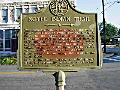
The Oakfuskee Path, main branch of the famous Upper Creek trading route from the Savannah River to the Creek Indians, passed here. Beginning at present Augusta, it led through Greenville...
- lat34
Noted Indian Trail
![The road from the east is a remnant of the Oakfuskee Path, main stem of the noted upper trading route from the Savannah River to the Creek Indians of Georgia and Alabama[.] Beginning at present...](http://lh3.googleusercontent.com/QV1RPKT31puc9PHvbftxOYEzunvrcaIomPa0s3fw-vZQQlTo7Ynv4Zvlyz9Pm2hpvRzs3w0mU8GXBUIepNkgHtTd2bM)
The road from the east is a remnant of the Oakfuskee Path, main stem of the noted upper trading route from the Savannah River to the Creek Indians of Georgia and Alabama[.] Beginning at present...
- lat34
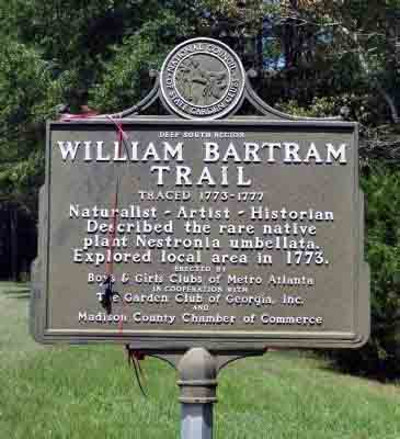
William Bartram Trail Traced 1773-1777

WILLIAM BARTRAM TRAIL TRACED 1773-1777 IN 1774 WILLIAM BARTRAM TRACKED OLD FEDERAL ROAD THROUGH FORT PERRY, GOING TO CAMP AT PINCHLUCCO (PINE KNOT CREEK) Plaque courtesy Lat34North.com....
- lat34
Church Hill

This name was given to the large settlement here because of its many churches. Shiloh Baptist, still active, was constituted in 1835. Smyrna Presbyterian, constituted July 28, 1838, was active...
- lat34
Old Courthouse-1848

This courthouse built in 1848 at a cost of $1,637 replaced one built in 1839 and was burned in 1845. The courthouse now in use was built at Buena Vista, then Pea Ridge, in 1850 when the...
- lat34
New Courthouse-1850

Built in 1850 of locally made brick, this is one of two courthouses standing in Marion County. The other built in 1848 is at Tazewell. The first courthouse was at Horry. When the county seat...
- lat34
Old Federal Road

The road crossing east and west here is The Old Federal Road Western Georgia´s first vehicular thoroughfare. Beginning at Fort Hawkins (now Macon) it led across the Creek Indian Country to the...
- lat34
Fort Perry-1813

One half mile due east lies the site of Fort Perry, along the Old Federal Road. A stockade fort, defended by block houses, this post was ordered erected by General John Floyd of Camden County, as...
- lat34
William Bartram Trail
— Deep South Region — William Bartram Trail Traced 1773 - 1777 Naturalist ~ Artist ~ Historian Described the rare native plant Nestronia umbellate. Explored local area in 1773. Erected by Boys and...
- lat34
Crawford Long Birthsite
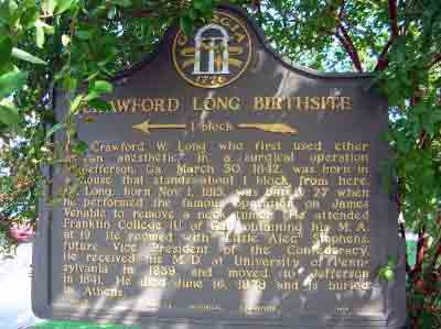
Dr. Crawford W. Long who first used ether as an anesthetic, in a surgical operation at Jefferson, Georgia, March 30, 1842, was born in a house that stands about 1 block from here. Dr. Long,...
- lat34
Madison County

This County, created by Act of the Legislature December 5, 1811, is named for James Madison, Virginia Democrat, fourth President of the United States, 1809-17. The site for Danielsville was given...
- lat34
Flint River Farms Resettlement Project

The Flint River Farms Resettlement Project was established by the U.S. Department of Agriculture Resettlement Administration in 1937. The Project was one of many similar community...
- lat34
Clara Barton
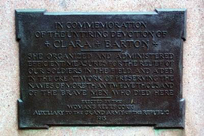
In Commemoration of the Untiring Devotion of Clara Barton ———— She organized and administered efficient measures for the relief of our soldiers in the field, and aided in the great work...
- lat34
Mt. Zion Lutheran Church

Organized as a Lutheran society by Pastor John D. Scheck in 1836, the church which came to be located here received its first pastor with the arrival of Father Jacob Kleckley in 1838. The initial...
- lat34
Lanier/Miona Springs
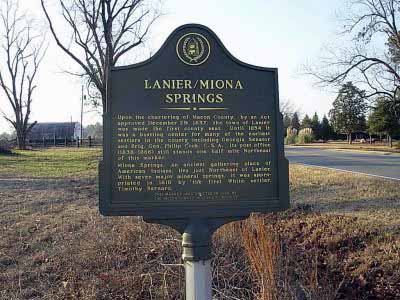
Upon the chartering of Macon County, by an Act approved December 29, 1837, the town of Lanier was made the first county seat. Until 1854 it was a bustling center for many of the earliest...
- lat34
View From A Pigeon- Roost

This photograph was taken in August 1861 from a sentry box just down slope from here. The photographer was A.J. Riddle, who was preparing a report for the Confederate government. Riddle's seven...
- lat34