
Casey's Hill

A notable eminence between Peachtree & Proctor´s creeks near the Chattahoochee River & named for John A. Casey (1820 - 1907) who lived on this hill near the old Montgomery Church. Prior to &...
- lat34
Johnston's Army Crossed the River
![July 5-9, 1864. Johnston Army of Tenn [CSA] held a fortified line N. of the Chattahoochee from Nickajack C r. to one mile above Peachtree Cr. Federal crossings several miles upriver July 8, making...](http://lh3.googleusercontent.com/Xms3AzkWBJwyb6TpsjlTKXK9LqGotZsJ71s4JTbvYmRx2ltTQYHwOE_GrRIHfZhg5lsSIjb1t9cZIW-U4emQ1YiEXbc)
July 5-9, 1864. Johnston Army of Tenn [CSA] held a fortified line N. of the Chattahoochee from Nickajack C r. to one mile above Peachtree Cr. Federal crossings several miles upriver July 8, making...
- lat34
Old Montgomery Fy. Rd.
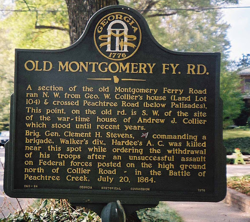
A section of the old Montgomery Ferry Road ran N.W. from Geo. W. Collier´s house (Land Lot 104) & crossed Peachtree Road (below Palisades). This point, on the old rd. is S.W. of the site of...
- lat34
Land Lot 104

The area E. (L. L. 104, 17th Dist.), long known as Collier´s Woods, was part of the ante-bellum plantation of George W. Collier (1813-1903). Clear Creek P.O. (1831-1839), probably in this land...
- lat34
Sector of Siege Line

55 yards. S.E. an intrenched line of field works crossed this block extending S.W. to 7th St., where it turned N.W. to Juniper at 11th St. This was a sector of the Federal sietge line occupied by...
- lat34
Stanley's Sector

N.E. of this point (near Highland School) was the intrenched line held by Federal forces in the siege of Atlanta, July 22-Aug. 25, 1864. This was the extreme left of Howard´s 4th A.C.; its...
- lat34
Augustus Hurt Plantation

The outer Confederate defense line of Atlanta, located on E. slope of this hill, July 18, was evacuated the night of the 21st, 1864. July 22. The Federal 23d A. C., under Schofield marching from...
- lat34
Isom's Ferry

Chattahoochee River, at mouth of Soap Creek, .75 mi. N.W., operated in the 1860´s by James Isom. Federal Army records cite it variously as Isham´s Ford or Ferry, Phillip´s Ferry, Cavalry Fd....
- lat34
Augustus Hurt House

200 yds. N.E. stood the plantation residence of Augustus F. Hurt (1830-1921), built 1858 and razed by Federal forces, 1864; erroneously cited in Official Records as the Howard house. July...
- lat34
Old Williams Mill Rd.

The old Williams Mill Rd. crossed the Fulton- DeKalb Co. line here; it was identical with Briarcliff to this point where it continued S.W., crossing Highland at North Avenue. July 20, 1864. The...
- lat34
Stevenson's Division
![A point in the intrenched line held by General Carter L. Stevenson´s division of the Cheatham´s (formerly Hood´s) A.C. [Confederate] ~ a sector of Atlanta´s outer defense line. July 18-22, 1864....](http://lh3.googleusercontent.com/5tLkN8ZlL2nhOWiHo4XlEnlrcZ_p5DPMzFX0VDd95nAosHHQ2dE8xUrkOgKFu8SxLjs7lUdSw3Y6x_EJJ8_7TOufsghq)
A point in the intrenched line held by General Carter L. Stevenson´s division of the Cheatham´s (formerly Hood´s) A.C. [Confederate] ~ a sector of Atlanta´s outer defense line. July 18-22,...
- lat34
Cheatham's Salient

At this point, Atlanta´s outer defense line, beginning at Casey´s Hill 5.75 mi. W., turned S. & parallel to Highland Ave., ran to the Ga. R.R. This angle was occupied July 18, 1864, by Stevenson´s...
- lat34
Wood's Div. 4th Corps

On adjacent hill was the right or western end of the intrenched line held by Gen. T.J. Wood´s div. of the Federal 4th A.C., July 20-22, 1864. The line extended E. 1.5 mile to intersection of...
- lat34
Stanley's & Wood's Sector

A point in the intrenched line of the Federal 4th A.C., July 20-22, 1864. Stanley´s & Wood´s divs. marched to this sector from Buckhead via Old Cheshire Bridge Rd., LaVista, Williams Mill...
- lat34
King's Brigade

July 20, 1864. In federal advances on Atlanta from N.E., a gap was left between the 23d A.C. (on Briarcliff Rd.) and Newton´s Div., 4th A.C. on Peachtree Rd. S. of the creek. Two 4th...
- lat34
Bate's Division

The outer Atlanta defense line crossed Clear Cr. a short distance S. W. of Walker´s (or Jones´) Mill (just below the present R.R. bridge). July 20, 1864, the right of Bate´s division (rt....
- lat34
Hardee's Attack
![July 20, 1864. At 3:30 P.M., 3 divisions of Hardee´s A.C., [CSA] Bate´s, Walker´s, & Maney´s, moved to the attack of newton´s 4th A.C. division [US] posted on the ridge 200 yards north of Collier...](http://lh3.googleusercontent.com/HrR_ALGC8e1fWdZj7WldDZx3JHqQBo7HE9pAY7iiU7HPwXjN2vJUWKKtj80MPTBykELq0AqxuR87C9VKv6fF8vOdJXw)
July 20, 1864. At 3:30 P.M., 3 divisions of Hardee´s A.C., [CSA] Bate´s, Walker´s, & Maney´s, moved to the attack of newton´s 4th A.C. division [US] posted on the ridge 200 yards north of Collier...
- lat34
Newton's Division

July 20, 1864. General John Newton´s division, Howard´s 4th A.C. marching south from Buckhead, relieved T. J. Wood´s division this side of Peachtree Creek and moved to this ridge where...
- lat34
McPherson's Troops March to Decatur

July 17, 1864. The three Federal armies, commanded by Gen. W. T. Sherman, having crossed the Chattahoochee River at Soap Creek, at Power´s and Pace´s ferries, & at Shallow Ford near Roswell, began...
- lat34
Loring's Hill
![July 20, 1864. The high hill, within the forks of Tanyard Branch, was occupied by troops of Maj. Gen. W.W. Loring´s Div. of Stewart´s A.C. [Confederate]. From this hill & a sector W. of it,...](http://lh3.googleusercontent.com/YC_3R1QtBbgvcoEIewJXgqFIp9MHSN_ch3A-6GgouKaKT0npWsWhFJPKu7NDpd2xX0WvjBG6LvkIJwakQAn6p2buYKs4)
July 20, 1864. The high hill, within the forks of Tanyard Branch, was occupied by troops of Maj. Gen. W.W. Loring´s Div. of Stewart´s A.C. [Confederate]. From this hill & a sector W. of...
- lat34