
Simeon Brinson 1847-1918 (Side 2)

The town of Brinson was named in honor of Simeon Brinson, a prominent farmer and businessman. Brinson, a native of Dougherty County, saw action during the War Between the Sates as a private...
- lat34
Bainbridge Army Air Field

In August, 1942, on this 2,053 acre tract, the U.S. Army constructed a basic flight training field. It remained open until 1945. At its peak 9600 officers, enlisted men, trainees and WACS were...
- lat34
Shade Grown Tobacco (Side 2)

Cigar wrapper tobacco was grown only in a small area of Georgia, Florida and the Connecticut River Valley from the 1840 s to 1975. During the 1890 s, wooden arbors began to be used to make the...
- lat34
Ira Sanborn

Decatur County´s first industrialist was Ira Sanborn, a native of Concord, New Hampshire. Born in 1799, Sanborn came to Apalachicola, Florida about 1830 and later resettled in Quincy,...
- lat34
Fort Hughes
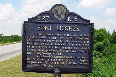
Four blocks west is the site of Fort Hughes, built in 1817, by the 7th Regiment of the U.S. Infantry under the command of Captain John M. McIntosh. This fort served as a protection for...
- lat34
First United Methodist Church

Founded in 1823, title to this property was conveyed to the church in 1830 by the Inferior Court, Bainbridge. An initial building was erected about 1840 and was also used during the 1850´s...
- lat34
First Presbyterian Church

The First Presbyterian Church once stood here. It was a handsome building with a lofty ceiling vestibule and three sided gallery. The lot was one-half acre in size, cost $110 and was bounded by...
- lat34
El Camino Real (The Kings Highway)

In this vicinity was the Indian trail which, during the period of Spanish occupation, became known as El Camino Real or King´s Highway. This road, connecting St. Augustine and Pensacola, Florida,...
- lat34
DeSoto Trail

In this neighborhood Hernando de Soto and his army discovered the inland waters of the Flint river (´the River of Capachequi´) on Friday, March 5, 1540. Leaving the vicinity of the...
- lat34
DeSoto Trail

1540 In this neighborhood Hernando de Soto and his army discovered the inland waters of the Flint river ("the River of Capachequi") on Friday, March 5, 1540. Leaving the vicinity of the...
- lat34
Cyrene Institute (Side 1)

This school was founded in 1909 by C. S. Hodges and W. G. Powell, at the Village of Cyrene, to provide preparatory education for boys. Later that year the curricula was expanded to provide...
- lat34
Amsterdam, Georgia (Side 1)

In 1891, A. Cohn & Company purchased 14,000 acres for tobacco cultivation and named it Amsterdam. At that time, the property was the largest tobacco plantation in the world, under one ownership....
- lat34
Fort Scott

In June 1816 Lt. Col. D. L. Clinch and a detachment of the 4th U.S. Infantry set up camp one mile west of here, calling it Camp Crawford. They began construction of a fort on the site in September...
- lat34
Decatur County

Decatur County was created by Act of Dec. 8, 1823 from Early County. Sessions were cut off later to form part of Seminole and Grady Counties. It was named for Stephen Decatur (1779-1820),...
- lat34
The Tonge Factory

The Tonge Factory, owned by S. D. Tonge, stood on the South bank of the Flint river one-fourth mile West of here. The cloth produced by this plant was used by the women of Bainbridge to make...
- lat34
Battle of 1702
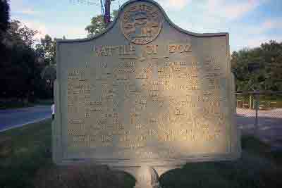
In this vicinity was fought the Flint Battle of 1702 between the English under Capt. Antonio with Creek allies from Achito (near Columbus) and the Spaniards under Capt. Francisco Romo Uriza...
- lat34
Georgians in the Union Army

Georgians in the Union Army The First Georgia Volunteer Infantry Battalion (U.S.), also known as the First Georgia State Troops Volunteers (U.S.), was a United States Army unit raised in Dawson...
- lat34
The Appalachian Trail

Here begins the approach trail to Springer Mountain, the southern terminus of the Appalcahian Trail, a continuous footpath extending more than 2,000 miles to Mt. Katahdin, Maine. The Appalachian...
- lat34
Dawson County

This County, created by Act of the Legislature Dec. 3, 1857, is named for William C. Dawson who died in 1856, having served in Congress from Dec. 1836 to Nov. 1842, and in the U.S. Senate...
- lat34
Chief Wauhatchie's Home

Just East of the railroad from here and 200 yards North of Wauhatchie Spring and Branch, stood the home of Wauhatchie, Chief of the Cherokees. In the War of 1812 he served in a company of...
- lat34